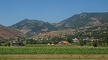
Rrajca
|
Rrajcë Rrajca |
||
|
Coordinates: 41 ° 5 ' N , 20 ° 35' E |
||
| Basic data | ||
|---|---|---|
| Qark : | Elbasan | |
| Municipality : | Përrenjas | |
| Height : | 690 m above sea level A. | |
| Residents : | 8421 (2011) | |
| Telephone code : | (+355) 0591 | |
| Postal code : | 3405 | |
Rrajca ( Albanian also Rrajcë ) is a town in the Elbasan Qark in eastern Albania . Until 2015 the place was the seat of the Komuna of the same name with 8,421 inhabitants, since then it belongs to the municipality of Përrenjas .
Geography and traffic
Rrajca is located around three kilometers northeast of Prrënjas on the edge of the small plain Fusha e Domosdovës in the mountainous east of Albania at around 690 m above sea level. A. The border with North Macedonia is less than two kilometers from the town; it runs on the ridge that separates the Shkumbin basin from that of Lake Ohrid , at 1250 m above sea level. A. and above. While the hills in the west of the village are not particularly high, the mountains in the north and east reach heights of almost 1,400 m above sea level. A.
The villages Sutaj, Skënderbej, Bardhaj, Katjel, Kotodesh and Uraka also belong to the administrative unit and former municipality of Rrajca. Sutaj is located one kilometer north at around 800 m above sea level. A. Skënderbej and Bardhaj are about ten kilometers further north in the Bushtrica valley on the other side of the Qafa e Policës pass (about 1230 m above sea level ) on opposite slopes. Kotodesh and Uraka are on the south-eastern edge of the plain. Katjel further to the west no longer belongs to Fusha e Domosdovës.
The SH3 , which belongs to the west-east transport corridor of Albania, runs a little south of the village and climbs in Uraka towards the east to the Qafë Thana pass ( 937 m above sea level ). An asphalt road leads to Sutaj. Katjel is also connected from Uraka via Kotodesh via an asphalt road.
The railway line from Prrënjas to Pogradec of Hekurudha Shqiptare , which was built in the second half of the 1970s and has since been shut down, runs in loops and gaining height across Rrajca, before entering the district of Kostriçan in Albania's longest railway tunnel and crossing under the pass.
nature
The Shebenik-Jablanica National Park is partially located in the territory of the former municipality. It starts at Qafa e Policës, the village of Skënderbej is entirely in the park. However, the region is difficult to access, isolated and very sparsely inhabited.
A 2129.5 hectare area a few kilometers north of Skënderbej was declared a World Heritage Site by UNESCO in 2017 . In this zone on the eastern slopes of the Shebenik ( 2261 m above sea level ) a large primeval beech forest has been preserved, which, together with 66 other forests in various countries, forms the World Heritage Old Beech Forests and Primeval Beech Forests of the Carpathians and other regions of Europe . The world heritage extends from a height of around 1200 meters to over 2000 meters. A buffer zone of 2569.75 hectares surrounds the reserve, an almost untouched forest with trees up to 180 years old. Although the forest area is about twelve kilometers from the village as the crow flies , it is also called Rrajca, like the mountain lakes Liqenet e Rrajcës located above the forest and declared a natural monument .
Several projects were carried out in Skënderbej to protect the beech forest. The local administration hopes for a tourist boom in the region, especially through recognition as a UNESCO World Heritage Site.
Web links
Individual evidence
- ↑ a b Ines Nurja: Censusi i popullsisë dhe banesave / Population and Housing Census - Elbasan 2011 . Results Kryesore / Main Results. Ed .: INSTAT . Pjesa / Part 1. Adel Print, Tirana 2013 ( document as PDF [accessed on April 28, 2019]).
- ↑ Bashkia Prrenjas. In: Këshilli i Qarkut Elbasan. Retrieved January 28, 2018 (Albanian).
- ↑ Hanns Kirchmeir, Anna Kovarovics (ed.): “Primeval Beech Forests of the Carpathians and Other Regions of Europe” as extension to the existing Natural World Heritage Site “Primeval Beech Forests of the Carpathians and the Ancient Beech Forests of Germany” (1133bis ) . Nomination Dossier to the UNESCO for the Inscription on the World Heritage List. Klagenfurt / Vienna January 2016, p. 22 ( unesco.org [PDF; accessed on January 28, 2018]).
- ↑ Euronatur , Protection and Preservation of Natural Environment in Albania (Ed.): Beech forests along the Green Belt in Albanian . 2017, p. 8th f . ( euronatur.org [PDF; accessed on January 28, 2018]).
- ↑ Euronatur , Protection and Preservation of Natural Environment in Albania (Ed.): Beech forests along the Green Belt in Albanian . 2017, p. 16 ff . ( euronatur.org [PDF; accessed on January 28, 2018]).
- ↑ A. Blloshmi: Në të mrekullitë e pasosura Rrajcës. In: Shoqata Egnatia. May 7, 2017, Retrieved January 28, 2018 (Albanian).


