
Rubihorn
| Rubihorn | ||
|---|---|---|
 Oberstdorf: Rubihorn (left) and Gaisalphorn |
||
| height | 1957 m above sea level NHN | |
| location | Bavaria , Germany | |
| Mountains | Thumb group , Allgäu Alps | |
| Dominance | 1 km → goat's foot | |
| Notch height | 95 m ↓ Niedereck | |
| Coordinates | 47 ° 25 '28 " N , 10 ° 18' 55" E | |
|
||

The Rubihorn is a 1957 meter high mountain in the Allgäu Alps . It is located east of Oberstdorf and, together with the Nebelhorn, belongs to the so-called thumb group .
Rockslide
On July 9, 1987, a rock fall occurred on the north side of the Rubihorn , in which between 10,000 and 15,000 m³ of rubble fell into the valley. The traces of this event can still be seen from afar.
Hiking trails
- Reichenbach (car park) - Gaisalpe (1165 m) - Unterer Gaisalpsee (1508 m) - summit (this variant takes about 3.5 hours, surefootedness and a head for heights are absolutely necessary)
- Nebelhornbahn (middle station Vordere Seealpe 1280 m) - Roßbichel (1465 m) - summit (with this variant you have already gained a lot of height by taking the Nebelhornbahn , but surefootedness and a head for heights are also required on this route)
literature
- Thaddäus Steiner : Allgäuer Bergnames , Lindenberg, Kunstverlag Josef Fink, 2007, ISBN 978-3-89870-389-5
- Thaddäus Steiner: The field names of the municipality of Oberstdorf im Allgäu , Munich, self-published by the Association for Field Name Research in Bavaria, 1972
- Zettler / Groth: Alpine Club Guide Allgäu Alps . Bergverlag Rudolf Rother , Munich 1984. ISBN 3-7633-1111-4
photos
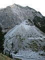
Rock fall on the Rubihorn
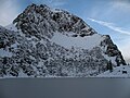
Above the Lower Gaisalpsee
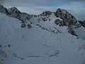
With Oberem Gaisalpsee
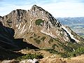
The east side of the Rubihorn


Web links
Commons : Rubihorn - collection of images, videos and audio files