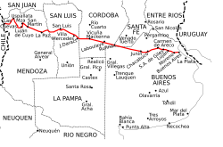
Ruta Nacional 7
The Ruta Nacional 7 - officially also Carretera Libertador General San Martín since Decree 115.261 from 1942 - is one of the most important east-west connections in Argentina and, together with the Ruta CH-60, forms the shortest land connection between the Pacific port of Valparaíso in Chile and Buenos Aires on the Atlantic .

course
The road - directly connected to the city center of the Argentine capital via the intersection-free access to the Autopista Perito Moreno and the Autopista 25 de Mayo - officially begins after crossing the capital's ring road, Avenida General Paz . It runs through the provinces of Buenos Aires , Santa Fe , Córdoba , San Luis and Mendoza , before ending after 1,224 kilometers in the Túnel del Cristo Redentor on the border with Chile.
history
The Camino Real del Oeste, which connected the cities of San Luis and Mendoza with these endpoints, originally ran between Buenos Aires and Santiago de Chile during colonial times . With the construction of a railway line between Buenos Aires and Mendoza in the late 19th century, the road connection lost its importance. It was only with the advent of the automobile in 1932 that the Dirección Nacional de Vialidad (National Directorate for Roads) was created by a resolution of the National Congress . In the course of the decisions of 1935, the construction of a street parallel to the 1910 line of Ferrocarril Buenos Aires al Pacífico (BA&P - later Ferrocarril General San Martín (FCGSM)) began; the route was assigned the number 7.
The fortification of the section between Chacabuco and Junín was completed in June 1942. The course of the road between Junín and Laboulaye was changed in 1968, the southerly route was opened on October 2, 1969 between Junín and Rufino , on October 28, 1969 between Rufino and Laboulaye. Work on expanding the route to the confluence of Ruta Nacional 8 near Villa Mercedes was completed in 1975. The remaining section to Mendoza had already been fortified in 1940.
The stretch between Mendoza and Uspallata - the Caracoles de Villavicencio - led over 365 bends at over 3000 meters over a promontory of the Andes and was no longer able to cope with the growing volume of traffic by the early 1960s at the latest. It was therefore decided to relocate the route to the valley of the Rio Mendoza . West of Uspallata, the work was largely completed in 1979, the opening of the Túnel del Cristo Redentor in May 1980 made the use of the still unpaved section between Las Cuevas and the Paso de la Cumbre obsolete.
Laguna La Picasa
Due to the rise in the level of Laguna La Picasa between 1998 and 1999, 14.5 km of the road between the towns of Aaron Castellanos and Diego de Alvear on the border between the provinces of Buenos Aires and Santa Fe were flooded. For this reason, vehicles had to make a detour of 32 km over unpaved roads. The lowering of the water level of the Laguna La Picasa is currently being carried out by a pumping station in Rufino, this station is to be supplemented by another, not yet built, south of the lagoon.
On February 1, 2006, work to rebuild the affected section of Route 7 began with the construction of a basalt dam from a quarry in the province of San Luis. The roadway is raised to a level of 2 meters above the highest water level in the lagoon, so the roadway is about 6 meters above the average water level. The dam contains three culverts, each spanned by 20 meter long bridges.
The section was opened to traffic on June 10, 2007.
