
Sârbi (Budeşti)
|
Sârbi Szerfalva |
|||||
|
|||||
| Basic data | |||||
|---|---|---|---|---|---|
| State : |
|
||||
| Historical region : | Maramures | ||||
| Circle : | Maramureș | ||||
| Municipality : | Budeşti | ||||
| Coordinates : | 47 ° 46 ' N , 23 ° 57' E | ||||
| Time zone : | EET ( UTC +2) | ||||
| Height : | 460 m | ||||
| Residents : | 923 (2002) | ||||
| Postal code : | 437071 | ||||
| Telephone code : | (+40) 02 62 | ||||
| License plate : | MM | ||||
| Structure and administration | |||||
| Community type : | Village | ||||
| Others | |||||
| City Festival : | 3rd day after Easter: "Joc la Șură" ( dance in the barn ) | ||||


Sârbi [ ˈsɨrbʲ ] ( Hungarian Szerfalva ) is a Romanian village in the municipality of Budeşti in the Maramureş district .
The village is located at an altitude of about 460 meters above sea level, east of the Gutâi Mountains . On the Cosău - a right tributary of the Mara - and on the county road (drum județean) DJ 186B, Sârbi is about 3.5 kilometers north of Budeşti.
The name of the village Sârbi is synonymous with the Romanian name for the Serbs .
population
The population of the village developed as follows:
| census | Ethnic composition | |||||||
|---|---|---|---|---|---|---|---|---|
| year | population | Romanians | Hungary | German | other | |||
| 1880 | 809 | 689 | 11 | 109 | 29 | |||
| 1920 | 1,000 | 888 | - | - | 112 | |||
| 1966 | 1,072 | 1,058 | 14th | - | - | |||
| 2002 | 923 | 922 | 1 | - | - | |||
Attractions
- In the vicinity of the village are the wooden churches Sf. Nicolae Sârbi Josani 1665 and Cuvioasa Paraschiva Sârbi Susani 1667, have meanwhile been declared a World Heritage Site by UNESCO .
- The property in the village with technical folk art is a listed building.
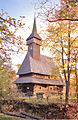
Sârbi Josani wooden church
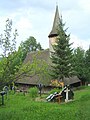
Sârbi Suzani wooden church

Water system of a yard

agricultural mill

.JPG)


Web links
Commons : Sârbi - Collection of images, videos and audio files
Individual evidence
- ↑ Census, last updated November 2, 2008, p. 173 (Hungarian; PDF; 1.1 MB)
- ↑ a b List of historical monuments of the Romanian Ministry of Culture, updated 2010 (PDF; 7.10 MB)
- ^ Film of the property with technical folk art in Sârbi on YouTube