Söderköping (municipality)
| Söderköping municipality | |||||
|---|---|---|---|---|---|
|
|||||
| State : | Sweden | ||||
| Province (län): | Östergötland County | ||||
| Historical Province (landskap): | Östergötland | ||||
| Main place: | Söderköping | ||||
| SCB code: | 0582 | ||||
| Residents : | 14,626 (December 31, 2019) | ||||
| Area : | 693.7 km² (January 1, 2016) | ||||
| Population density : | 21.1 inhabitants / km² | ||||
| Website : | www.soderkoping.se | ||||
| List of municipalities in Sweden | |||||
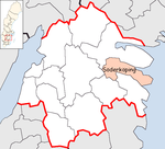
Coordinates: 58 ° 29 ' N , 16 ° 20' O Söderköping is a municipality ( Swedish kommun ) in the Swedish province Östergötland County and the historical province Östergötland . The main town of the municipality is Söderköping . Other localities are Östra Ryd, Snöveltorp, Västra Husby and other smaller villages.
geography
Söderköping is a coastal municipality on the Baltic Sea . The coast is characterized by the numerous offshore archipelago (Sankt Annas skärgård) , of which the inland archipelagos are used for agriculture. Apart from the strongly indented coastal area and the Slätbaken bay, which extends deep into the country on the northern municipal boundary, the municipality is characterized by a hilly landscape. While the hills are mostly forested, the valleys are open and used for agriculture.
economy
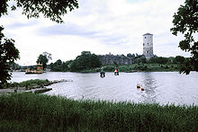
Agriculture and industry play only a modest role in the community. The most important branch of the economy is tourism, which has a long tradition due to the archipelago, the Göta Canal and the spa in Söderköping. The Stegeborg castle ruins , the birthplace and residence of King Johan III, are located directly on the coast . was.
Web links
Individual evidence
- ↑ Folkmängd i riket, län och kommuner December 31, 2019 at Statistiska centralbyrån
- ↑ Kommunarealer January 1, 2016 at Statistiska centralbyrån (including all inland waters)


