Sai (river)
| Sai | ||
|
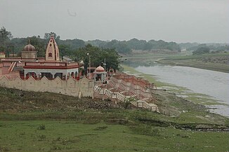
Bela Bhawani Temple on the banks of the Sai in Bela Pratapgarh |
||
| Data | ||
| location | Uttar Pradesh ( India ) | |
| River system | Ganges | |
| Drain over | Gomti → Ganges → Indian Ocean | |
| origin | in the Hardoi district 27 ° 46 ′ 0 ″ N , 80 ° 9 ′ 0 ″ E |
|
| muzzle | southeast of Jaunpur in the Gomti coordinates: 25 ° 39 ′ 6 ″ N , 82 ° 48 ′ 6 ″ E 25 ° 39 ′ 6 ″ N , 82 ° 48 ′ 6 ″ E
|
|
| length | 563 km | |
| Medium-sized cities | Raebareli , Bela Pratapgarh | |
The Sai ( Hindi : सई Saī [ sʌi ]) is a 563 km long river in the northern Indian state of Uttar Pradesh . It flows into the Gomti , which in turn is a tributary of the Ganges .
The Sai rises in the Hardoi district in central Uttar Pradesh and flows between the courses of the Ganges and Gomti, parallel to these two larger rivers, in a south-easterly direction through the Ganges plain . It crosses the Hardoi, Unnao , Raebareli , Pratapgarh and Jaunpur districts . The cities of Raebareli and Bela Pratapgarh are on the banks of the Sai. The Sai flows into the Gomti 16 kilometers southeast of Jaunpur .
