
Sancti Spiritus
| Sancti Spiritus | |
|---|---|
|
Coordinates: 21 ° 56 ′ N , 79 ° 27 ′ W
Sancti Spíritus on the map of Cuba
|
|
| Basic data | |
| Country | Cuba |
| province | Sancti Spiritus |
| City foundation | 1514 |
| Residents | 138,504 (2012) |
| Detailed data | |
| Population density | 121.3 inhabitants / km 2 |
| height | 75 m |
| prefix | + 53-41 |
| Time zone | UTC -5 |

The central Cuban city of Sancti Spíritus has 138,504 inhabitants (2012 census) and has been the capital of the province of Sancti Spíritus since 1976 . It is located at the foot of the Sierra de Sancti Spíritus on the largest country road on the island, the Carretera Central , about 50 km from the port of Trinidad . The city is the trading center of an agricultural area that processes sugar cane , tobacco and dairy products.
Sancti Spíritus is one of the seven cities founded by the Spanish conquistador Diego Velázquez de Cuéllar . The order to build it on the Rio Tuinicú was issued in 1514. Two years later, the structure was completed, but in 1524 it was moved to its current location on the Rio Yayabo . In 1719 she was sacked by English and French corsairs . The city gained wealth through the cultivation of sugar cane with the exploitation of African slaves .
The old town has a colonial character. The two squares Parque Honorato and Parque Sánchez in the city center are named after the heroes of the wars of independence Honorato del Castillo Cancio and Serafin Sánchez . The Iglesia del Espíritu Santo at Parque Honorato was built from wood as early as 1522. The church was later burned down when looted by pirates in the 17th century and rebuilt in stone. Today the city is the seat of a university. In 2002, parts of the city were hit by Hurricane Lili .
On February 24, 2017, the railway accident at Sancti Spíritus occurred .
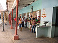
Impressions from Sancti Spíritus

Street business

Street scene

Museo de Arte Colonial

front door

Pedestrian zone

State agricultural market
State agricultural market

cathedral

cathedral

“The Last Supper”, Cathedral


sons and daughters of the town
- Eglys Cruz (* 1980), marksman
- Ana Ibis Fernández (* 1973), volleyball player
- José Miguel Gómez (1858–1921), President of the Republic
- Miguel Mariano Gómez (1890–1950), politician
- Jorge Gonzalez (* 1967), choreographer and model
- Yumari González (* 1979), cyclist
- Yosvany Veitía (* 1992), boxer