Santa Clara River
| Santa Clara River | ||
|
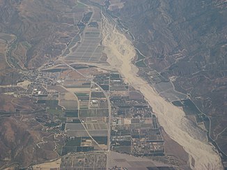
Bird's eye view of Santa Clara River |
||
| Data | ||
| location | California (USA) | |
| River system | Santa Clara River | |
| source | in the San Gabriel Mountains | |
| muzzle | at Oxnard in the Pacific Coordinates: 34 ° 13 ′ 48 " N , 119 ° 15 ′ 36" W 34 ° 13 ′ 48 " N , 119 ° 15 ′ 36" W |
|
| Mouth height |
0 m
|
|
| length | 186.7 km | |
| Catchment area | 4143 km² | |
The Santa Clara River is a 186 km long river in Los Angeles County and Ventura Counties in the southern US state of California .
The Santa Clara River has its source near Acton in the San Gabriel Mountains . It then crosses the Santa Susana Mountains in the Santa Clarita Valley and flows into the Santa Clara River Estuary Natural Reserve between Ventura and Oxnard in the Pacific. It drains an area of 4,143 square kilometers. A tributary of the Santa Clara River, Sespe Creek , is one of the few rivers in Southern California to be designated a National Wild and Scenic River .
Web links
- Santa Clara River on the United States Geological Survey's Geographic Names Information System
- Santa Clara River Estuary Natural Reserve , website of the State of California (English)
