
Machine fleet
Machine fleet between Bremen west and Blockland |
_location_map.svg)
The Maschinenfleet is a 6.6 km long artificial watercourse in Bremen and forms the border between the blockland in the east and the districts of Gröpelingen and Burglesum in the west. Before it was given its current name as a supply line to Bremen's most powerful pumping station , it was confusingly known as " the old dike " since it was first mentioned in 1374 .
Waller Siel and the ditch "The old dike"

On October 31, 1374, the dean and chapter of the Bremen Cathedral as well as the mayor and the councilors of the city of Bremen confirmed an agreement of eight downstream on the right bank of the Weser, as well as in the east bordering marshland on Lesum and Wümme , on the construction and maintenance of the Lesum dike between Grambke and Wasserhorst (“Neuer Deich”) with the Waller sluice and the drainage ditch called “Alter Deich” to be diverted from this sluice.
It is expressly mentioned that the sewer has yet to be created. The course of the trench is also described. The neighbors should not only maintain (“fetch”) their bank sections; if the field does not dry up immediately, you have to “make” it first, i.e. at least deepen it significantly.
The Waller Siel was roughly at the site of today's Wasserhorst pumping station and is not expressly named "Waller Siel" in the document from 1374. From the distribution of the maintenance burden on the farmers of the eight villages it becomes clear that the - at that time new - Lesum dike with sluice and efficient drainage ditch was a joint project of the whole region.
It is not clear from the document why the ditch was called "the old dike". It is believed that it followed the course of a dike that the elder colonists had built at the lower Kleiner Wümme and Wümme at the rear end of the areas they reclaimed. Now, with the construction of the sewer, the residents on both sides were interested in good drainage towards the ditch. An accompanying small dike, as postulated by Georg Garbade in his 1995 home history of the Blockland, would have hindered the drainage. In the first exact map of the Bremen area, drawn and published by CA Heineken in 1798 , nothing of the kind is entered. It cannot be ruled out that such a dyke existed in the course or next to the water until 1374. In addition to the drainage, the residents had another reason to remove a dam that was no longer needed; from reports of various dike breaches it becomes clear that earth was scarce to restore the dykes and to raise the height of the dikes.
Beginnings of active drainage
The silting up of the Lower Weser did not only cause difficulties for shipping to and from Bremen. By increasing the cross-section of the river as a whole, it also worsened the drainage possibilities of the marshes on the Lesum and lower Wümme. After dike breaches or heavy rainfall, extensive areas of the blockland were often under water for months, sometimes years.
In 1610 several locations were chosen for wind-powered scoop mills, in the sense of a decentralized active drainage. How many of these were realized is unclear. A chronicler complained that they had expired during the time of the Swedish governorship over Bremen (i.e. after the Peace of habenhausen ). A scoop mill was built on Dammsiel in 1770, but it did not work effectively. In the justification for the construction of a combined scoop and grain mill in Borgfeld , a previous improvement in the harvests in the area of weathering (land between the Kuhgraben and the Sietwenje, an older body of water next to today's Semkenfahrt ) is mentioned.

Drainage plant and machine fleet

On September 10, 1856, the Bremen Senate then passed the resolution to drain the entire Blockland and Hollerland area with steam power. The drainage facility was built on Waller Siel, which was moved back a few meters for this purpose. The feeding ditch "Alter Deich" was expanded to the machine fleet and connected by a cross channel with the confluence of the Waller Fleet in the Kleine Wümme . Since then, most of the water from the marshland east of the Bremen dune has been channeled through this machine fleet.
Some areas of the blockland had previously been under water so often and for so long that there was no turf left there. It took up to ten years of consistent drainage before they could be farmed again.
Due to the drainage, the soil level in the block land fell by 10 cm in the first seventy years. Over time, you realized that you couldn't just drain. Even before nature conservation was one of the tasks of the dyke association, water began to be supplied to Hollerland and Blockland in the winter months so that undesirable substances from the groundwater were not pressed into the vegetation layer from below.

Wasserhorst pumping station, Sieltor 1862/64 to 1987
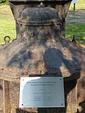
Wasserhorst pumping station, base of a three-phase motor from 1928
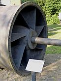
Rotary parts (moving parts) of a tubular casing pump


Further development

As early as 1924 the drive of the drainage system was converted from steam engines to electric motors. The motors and pumps, which then operated until the 1980s, were not installed until 1928.
In 1965 a pumping station was also put into operation at Kuhsiel .
In 1984–1987, a new pumping station was built at the mouth of the machine fleet a few meters east of the old systems, the machine rooms of which were integrated into the dyke body. The system has several pumping stations with turbines and several sluice channels for passive drainage. If possible, most of the drainage runs through this over time. They each have an electronically controlled, vertically adjustable slide with which the water drains are individually regulated, as well as swing gates that open towards the Lesum and are controlled by flow and water pressure.
Remains of the sewer system from the 19th century have been preserved on the landside of a new section of the dike. In addition to a corner of the wall of the pump house, parts of the old pumps are also exhibited as a freely accessible open-air museum.
Significance for the water balance in Bremen
On average between 2002 and 2013, 25,368,341 m³ drained through the sewage systems of the Wasserhorst pumping station into the Lesum and 11,349,440 m³ were pumped into the Lesum, a total of 36,717,781 m³ annually. The Kuhsiel pumping station pumped only 1,001,277 m³ into the Lesum as an annual average. Today the entire water discharge of the dike association on the right bank of the Weser from the catchment area of the small Wümme goes through these two pumping stations . The catchment area of the machine fleet does not cover 26.94 km², as stated in the area index for the Lower Saxony hydrographic map , but 103.22 km² including the catchment areas of the waters erroneously entered as independent Wümme tributaries. A part of the surface water from this catchment area does not appear in the systems of the dyke association and not in its documentation: A large part of the rainwater on sealed surfaces ends up in the municipal mixed water sewer system of Hansewasser . It is pumped under the Weser into the Seehausen sewage treatment plant and is included in its throughput of 47,450,000 m³ per year, which more than doubles on rainy days compared to the overall average.
swell
- Michael Ehrhardt / Landschaftsverband Stade “To protect the banks of the country” - On the history of the dikes on the Unterweser , ISBN 978-3-931879-59-4
- Georg Garbade: Home History of the Blockland , 1995
- Heinrich Hoops: The History of the Bremen Blockland , 1927
Web links
- http://www.geoviewer.umwelt.bremen.de/
- Dyke association on the right bank of the Weser: water level from human hands (PDF)
- Bremischer Deichverband on the right bank of the Weser: Wasserhorst pumping station
Individual evidence
- ↑ http://brema.suub.uni-bremen.de/content/pageview/26159 Bremisches Urkundenbuch III, No. 463 (p. 422/423): Confirmation of the agreement on the installation of the Waller Siels
- ↑ Gabriele Hoffmann: 900 years of wet feet (available in the magazine of the State Archives Bremen)
- ^ Environment Lower Saxony - Area Directory Weser