
Schalwand (Alps)
| Formwork wall (or black wall) | ||
|---|---|---|
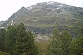
 Formwork wall from the east |
||
| height | 2942 m above sea level A. | |
| location | Tyrol , Austria | |
| Mountains | Ötztal Alps | |
| Dominance | 4.7 km → Großer Dristkogel | |
| Notch height | 197 m ↓ Scharte between Peischlkopf and Wallfahrtsjöchl | |
| Coordinates | 47 ° 5 '22 " N , 10 ° 46' 31" E | |
|
||
| rock | Veteran | |
| First ascent | July 28, 1900 by Rudolf L. Kusdas (tourist) | |
| Normal way | South ridge (I) | |

The Schalwand is a mountain of the Kaunergrat , a mountain range of the Ötztal Alps . At 2942 m, it is the highest mountain on the front Kaunergrat and is only surpassed in height to the south by the Großer Dristkogel , which is the first three-thousand-meter peak on the ridge. The formwork wall stands out due to its wide, mighty rock structure. Its ridge, moving northwards, slopes only slightly from the summit in the south. Seen from the Brechseekar, the mountain is reminiscent of a gigantic eggshell, which may have earned it its somewhat strange name. It is also known under the name Schwarzwand because it has conspicuous black rock layers at the approach of the convex flank. The scarf wall dominates the panorama of the front Kaunergrat due to its height and thickness. It is in front of the main ridge of the Kaunergrat towards the Pitztal .
Ascension story
On July 28, 1900 trod Rudolf L. Kusdas by the High Aifnerspitze coming he reached the two insignificant Graterhebungen of Hochschalterngrates that the further towing to the south ridge. About Köpfle border, to the foothills of the Stupfarri . Coming from there he finally climbed the summit, then known as "Schalenberg", over the south side.
Routes
The normal route leads from the Mauchelealm on a marked trail to the Brechsee . Follow the marked trail over steep mountain slopes and scree terraces in the direction of the Krummen See , which you can reach after about an hour from the Brechsee. Cross the scree slopes of the Mulde to the other side of the lake, to where a steep line of walls descends from the Stupfarriköpfle to the north. On the scree slopes above the lake under the wall section until the craggy slopes on the left allow the ascent. Over scree fields and crags to the hollow of the Upper Krummen See , at the eastern end of which the steep ridge runs up to the summit of the Schalwand. Along the edge of the lake to the blocky ridge flank and east over blocks up to the ridge (I). Now over the wide but sometimes steep ridge to the summit with Steinmann.
photos
Scarf wall from the Brechseekar

Schalwand from the Aherkogel (from the south)

On the south ridge of the Schalwand


literature
- Walter Klier : Alpine Club Guide Ötztaler Alpen , Bergverlag Rudolf Rother , Munich 2006. ISBN 3-7633-1123-8
- Ludwig Obersteiner: Guide through the Ötztal Alps , Reichenstein-Verlag, Vienna 1925
Individual evidence
- ^ Ludwig Obersteiner: Guide through the Ötztal Alps . Reichenstein Verlag, 1925, p. 118