Sheikh lace
| Sheikh lace | ||
|---|---|---|
|
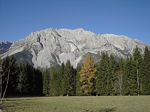
Scheichenspitze seen from Ramsau |
||
| height | 2667 m above sea level A. | |
| location | Styria , Austria | |
| Mountains | Dachstein massif , Dachstein mountains | |
| Dominance | 1.9 km → Koppenkarstein | |
| Notch height | 194 m ↓ Edelgriessscharte | |
| Coordinates | 47 ° 27 '2 " N , 13 ° 39' 21" E | |
|
|
||
| rock | Wetterstein lime | |
| Age of the rock | Triad | |
| Normal way | north from the Landfriedtal | |
The Scheichenspitze ( 2667 m above sea level ) is a summit of the Dachstein massif in Styria .
location
The Scheichenspitze rises a good three kilometers north of the main settlement of the municipality of Ramsau am Dachstein . As the southernmost high summit of the Dachstein Mountains, it stands directly above the Ramsau high plateau and is therefore also known as its "local mountain". To the south, three rock arms extend from the Gamsfeldspitze in the west, the Scheichenspitze and the Hohe Rams in the east, which enclose the two cirques "Fluder" in the west and "Eiskar" in the east.
Climbs
The easiest way to climb the Scheichenspitze is on a marked alpine path from the Landfriedsattel in the north.
The Ramsau via ferrata , built in 1986, is much more demanding and leads from the Gruberscharte to the Hohe Rams in an east-west direction and then runs on the long ridge over the Scheichenspitze, the Schmiedstock and the Hohen Gamsfeldspitz to the Edelgriesshöhe . "Due to the high alpine location, the sporty routing and the length of the climb, this is a company that should not be underestimated and is unsuitable for inexperienced mountaineers who do not suffer from vertigo."
The ascent from Guttenberghaus 2 kilometers east of the summit takes 2 to 2½ hours.
literature
- Kurt Schall: Via ferrata atlas Austria , Schall-Verlag, Alland 2011, 4th edition. ISBN 978-3-900533-63-2
Individual evidence
Web links
- Ramsau via ferrata : Description at www.bergstieg.com

