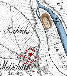
Meetschow castle wall
|
|
|
|---|---|
| Burgwall von Meetschow I on a map of the Electoral Hanover land survey around 1780, location of Burgwall Meetschow II marked in the red circle afterwards |
When Burgwall of Meetschow there are two north-east of Meetschow in Lower Saxony located medieval fortifications, of which except elevations no remains have survived. The complex, known as Meetschow I, was a ring wall built in the 10th century , which was transformed into a tower hill castle in the 13th century . In the immediate vicinity there was a Slavic rampart from the 10th century, which is called Meetschow II. Both fortifications were not far from the Elbe on a small peninsula formed by the Laascher See and the Leipgraben .
Meetschow I
The Meetschow I castle wall has been known for a long time because its elevation represents a striking landmark in the flat valley. The first archaeological excavations took place in the 1970s. During recent excavations in 2005, construction timbers were found that were preserved in the groundwater area under the exclusion of oxygen. According to their dendrochronological dating, the construction of the castle ramparts began in 906 and was completed in 910. It initially consisted of a 10 meter wide and around 3 meter high ring wall, which formed an interior space around 25 meters in diameter. The wall was a wooden box construction filled with soil. The system had five construction phases in three usage phases, which were based on destruction by floods, fire or expansion. Around the year 1000 the ramparts were temporarily abandoned and in the 13th century it was converted into a tower hill castle with a double moat. Due to the leveled soil of the wall, the castle hill expanded to a diameter of 80 meters. After the site was watered down, the castle was finally abandoned in the 14th century.
Meetschow II
The castle wall Meetschow II ( 53 ° 3 '5.7 " N , 11 ° 23' 41.4" O ) was added at geophysical Prospektionsmaßnahmen with GPR and geomagnetic discovered the castle walls Meetschow I in the immediate environment and archaeological examined in of 2006. It is located about 100 meters south on the banks of Lake Laasch and is no longer visible on the surface because it is leveled. One half of the castle ramparts has already been eroded by the lake through which the Seege waters flow. The rampart had a 7.5 meter wide wall and an interior space with a diameter of 45 meters. Finds of Middle Slavic ceramics from the 10th century made it possible to assign the facility to a use by Slavs . The archaeologists date it to around the year 950. There were traces of destruction by fire. It is still not clear whether the two castle walls existed at the same time or one after the other. According to one hypothesis, the Meetschow I castle wall could have been destroyed by a flood, which could have led to the construction of the Meetschow II castle wall 1.6 meters higher.
Schezla settlement
During the archaeological investigations, only a little south of the Meetschow II castle wall, the remains of a settlement were found that dates back to the 8th century and existed before the ring walls were built. The settlement was secured by a section wall. Based on the finds, it is attributed to a Saxon as well as a Slavic population. During the excavations, around 16,000 bone remains of animal origin were found, which were food and slaughterhouse waste. It is assumed that this is the border town "Skaesla" ( Schezla ) mentioned in the Diedenhofen capitular in 805 .
See also
literature
- Meetschow, castle. In: Wolfgang Juerries , Berndt Wachter (Ed.): Wendland-Lexikon . Volume 2: L – Z (= series of publications of the Lüchow-Dannenberg Local History Working Group. 13). Druck- und Verlagsgesellschaft Köhring & Co., Lüchow 2008, ISBN 978-3-926322-45-6 , p. 106.
- Jens Schneeweiß: New considerations on the localization of Schezla in: Archaeological reports of the district of Rotenburg (Wümme) 16, 2010, pp. 119–161 ( online )
- Martin Posselt, Jens Schneeweiß: The geophysical prospections of the years 2005/2006 on the castle wall of Meetschow. In: Karl-Heinz Willroth , Jens Schneeweiß (Hrsg.): Slawen an der Elbe (= Göttingen research on prehistory and early history. 1 = series of publications of the local history working group Lüchow-Dannenberg. 19). Wachholtz, Neumünster 2011, ISBN 978-3-529-01561-8 , pp. 103-119.
Web links
- Entry by SandyBieler and Stefan Eismann on Meetschow, Motte in the scientific database " EBIDAT " of the European Castle Institute
- Entry by SandyBieler and Stefan Eismann on Meetschow, Ringwall in the scientific database " EBIDAT " of the European Castle Institute
- Brief description of Burgwall Meetschow I and II
- Description of the excavations in 2006 and 2007 with aerial photos of the sites
Individual evidence
- ↑ Jens Schneeweiss: Where was Schezla? A forgotten border town of the early 9th century in: Babette Ludowici (Ed.): Saxones , Theiss, Darmstadt 2019, pp. 287–289
Coordinates: 53 ° 3 ′ 11 ″ N , 11 ° 23 ′ 31 ″ E

