
Petershagen lock
| Petershagen lock | ||
|---|---|---|
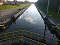
 Petershagen lock, view from the north |
||
| location | ||
|
||
| Coordinates | 52 ° 24 '55 " N , 9 ° 1' 33" E | |
| Country: |
|
|
| Place: | Petershagen | |
| Waters: | Weser | |
| Water kilometers : | km 223.10 | |
| Data | ||
| Owner: | Federal Waterways and Shipping Administration | |
| Responsible WSA : | WSA Verden | |
| Construction time: | 1934-1953 | |
| Start of operation: | 1953 | |
| lock | ||
| Type: | massive one-chamber lock | |
| Is controlled by: | Remote control center Minden | |
| Usable length: | 212 m | |
| Usable width: | 12.34 m | |
| Average height of fall : |
6.00 m | |
| Upper gate: | Miter gate | |
| Lower gate: | Miter gate | |
| Others | ||
| Associated weir: | Petershagen barrage | |
| Was standing: | August 2015 | |

The Petershagen lock is a lock near the East Westphalian town of Petershagen in North Rhine-Westphalia . It is part of the Petershagen barrage, which enables the Mittelweser to be expanded for inland shipping with a diving depth of 2.50.
history
In 1934, the Reichswasserstraßenverwaltung began with the expansion of the Mittelweser between Bremen and Minden in order to achieve a shipping route between the North Sea ports in Bremen and the hinterland as well as with the Mittelland Canal in Minden. Due to the war, construction had to be stopped in 1941. After the Second World War, the lock was completed and put into operation together with the Petershagen barrage in 1953.
In the course of the expansion of the Mittelweser for large motor ships , some construction work was necessary at the Petershagen lock.
location

The Petershagen lock canal with the Petershagen lock shortens a loop of the river Weser near Petershagen. The length of the canal is 8.30 km, the Petershagen lock is 6.957 km. In relation to the Weser, the lock is at river kilometer 223.10. By building the canal to the right of the Weser, the Petershagen districts of Jössen and Windheim were placed on an island between the canal and the Weser. Today they can be reached via several canal bridges.
island

A bend in the river Weser was separated by the lock canal, which was completed on November 30, 1948 . The result was an island with an area of around 950 hectares with around 1,730 inhabitants (resulting in an average population density of 182 inhabitants per km²). The island is 7.3 km long and at its widest point it measures 2.3 km. The total length of the bank is 18 km. In the north of the island there are 15 quarry ponds of different sizes. With a total water area of around 80 hectares, they take up around one twelfth of the island's area. In three of these lakes there are again a total of 6 islands and islets. The largest of these islands is an approximately 0.32 hectare sandy island with no significant vegetation; the smallest is an oval islet with an area of just under 30 m², which nevertheless has a small population of trees. The proportion of forest is very small on the island and barely covers 20 hectares. The majority of the forests are in the north around the aforementioned quarry ponds. Otherwise the island is mainly used for agriculture, with arable land predominating. The much less extensive grassland runs in the course of the Weser and also around the quarry ponds in the north.
There is a campsite on the southern tip of the island .
The districts of Windheim in the north and Jössen in the middle are on this island . (Although the boundaries of the administrative districts extend beyond the lock canal to the east, the actual housing estates are almost exclusively on the island).
Although there are similar examples in Germany of an artificial island by river straightening, such as B. the Kühkopf in Hessen , a name for this Weser island has not yet developed and an "island awareness" has hardly developed.
A smaller Weser island with an area of around 590 hectares was created in a similar way near (or rather around) the town of Schlüsselburg in the north of the aforementioned city of Petershagen in the border area with Lower Saxony . Here, too, an arm of the Weser was separated by a lock canal.
Technology of the lock
The lock Peter Hagen, together with the Mittelweser locks Schlüsselburg remotely, Landesbergen and Drakenburg of Minden from, so no operator is required on site. With the exception of the Dörverden lock, the six locks in the Middle Weser are all identical, the only difference being the different water levels. The upper and lower gates are designed as double-leaf mortise gates with a bolted construction. The goals have a baffle on top and diagonal struts.
Specialty

Is located at the lock a mailbox of Deutsche Post , which is emptied daily.
gallery
The lock with the upper gate open as seen from the lower head

The lock seen from the head

Head of the lock with the former wheelhouse


Web links
Individual evidence
- ^ WSA Verden: The Petershagen lock , accessed on August 11, 2015.
- ↑ ELWIS: Inland Waterways of the Federal Republic of Germany, Section III ( Memento of the original from October 5, 2015 in the Internet Archive ) Info: The archive link was inserted automatically and has not yet been checked. Please check the original and archive link according to the instructions and then remove this notice. , accessed on August 11, 2015.
- ^ City of Petershagen: Lock Windheim , accessed on August 11, 2015.
- ↑ Statement on the website of the city of Petershagenː "After the lock canal was built, the localities of Jössen and Windheim became, so to speak, island locations"
- ↑ Mention of the island in the Mindener Tageblatt on July 29, 2009
- ↑ Data determined from residents of NRW - online calculator
- ↑ Mention of the island on a tourist leaflet as "idyllic island between the Weser and the canal"
- ↑ WSA: Information 2008 - 2009 , accessed on August 11, 2015.
- ↑ WSA: Informations 2008 - 2009 , page 63, accessed on August 11, 2015