Schloßberg (Schönstein)
| Schlossberg | ||
|---|---|---|
|
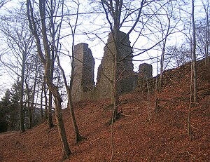
The Schönstein castle ruins |
||
| height | 419 m above sea level NHN | |
| location | near Schönau ; Schwalm-Eder-Kreis , North Hesse ( Germany ) | |
| Mountains | Upper Hessian threshold | |
| Coordinates | 50 ° 58 '52 " N , 9 ° 4' 2" E | |
|
|
||
| particularities | Castle ruin Schönstein | |
The Schloßberg is 419 m above sea level. NHN high mountain of the Hemberg ridge ( 470.6 m ). It is located near Schönau , a district of the community Gilserberg , in the Schwalm-Eder district in northern Hesse . It is completely forested.
geography
location
The Schloßberg rises in the Kellerwald-Edersee nature park between the Gilserberg districts of Schönau in the south and Schönstein in the north-north-west; it belongs to the district of Schönau. The mountain is part of the western roof of the Hemberg ridge. Its eastern neighbor is the Hundskopf ( 470.6 m ), the highest point on the Hembergs. The mountain is passed south, west and north of the Gilsa .
Natural allocation
The lock mountain belongs in the natural environment feature unit group West Hesse Highlands (no. 34) and in the main unit Oberhessische threshold (346) for subunit Gilserberger heights (346.0) that North-South direction of the cellar forest in the Vogelsberg connects. The landscape leads west to northwest into the natural area Jeust and Keller (344.00), which belongs to the main unit Kellerwald (344) and its subunit Hoher Kellerwald (344.0), and to the northeast into the nearby subunit Löwensteiner Grund (341.7).
Castle ruin Schönstein
On the western spur of the Schloßberg, the steep slopes of which rise more than 60 m above the Gilsa, are the ruins of Schönstein Castle ( 360 m ), probably built in the 12th century and badly damaged in the 16th century . Remnants of the wall of the main building are still present.
Traffic and walking
A little to the west past the Schloßberg, beyond the Gilsa between Schönstein and Schönau, the district road 3425 runs, which runs southeast to a crossing of the federal road 3 near Sebbeterode . The Kellerwaldsteig runs between the summit region of the mountain and its western spur with the Schönstein castle ruins , which previously leads past Schönstein, over the Hemberg ridge and past Schönau.
Individual evidence
- ↑ a b Map services of the Federal Agency for Nature Conservation ( information )
-
^
Gerhard Sandner: Geographical land survey: The natural space units on sheet 125 Marburg. Federal Institute for Regional Studies, Bad Godesberg 1960. → Online map (PDF; 4.9 MB);
Note: in sheet 125 of the southwest part of the natural environment is 341.7 (Löwensteiner reason) accidentally 343.11 (Country Burger sink) referred - ↑ Martin Bürgener: Geographical Land Survey: The natural spatial units on sheet 111 Arolsen. Federal Institute for Regional Studies, Bad Godesberg 1963. → Online map (PDF; 4.1 MB)
- ↑ Die Einsame im Wald , HNA, from August 17, 2014, on hna.de.

