Schnarrenberg (Tübingen)
| Schnarrenberg | ||
|---|---|---|
|
View from the Steinenberg tower past the Schnarrenberg (left) with the University Clinic Tübingen (UKT) there and over Tübingen in an east to south-east direction to the Swabian Alb |
||
| height | 450 m above sea level NHN | |
| location | in Tübingen ; District of Tübingen , Baden-Württemberg ( Germany ) | |
| Mountains | Schönbuch | |
| Coordinates | 48 ° 31 '50 " N , 9 ° 2' 24" E | |
|
|
||
| particularities | University Hospital Tübingen | |
|
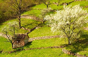
Opened vineyard with terracing of the slope on the western slope of the Schnarrenberg in Tübingen- Weststadt |
||

The Schnarrenberg in the urban area of Tübingen in the Baden-Württemberg district of Tübingen is about 390 to 450 m above sea level. NHN high eastern foothills of the Steinenberg ( 492 m ). It is largely dominated by the buildings of the University Hospital Tübingen (UKT).
geography
location
The Schnarrenberg is part of the southern roof of the Schönbuch and is located about 1.5 km (as the crow flies ) northwest of the center of Tübingen . Its landscape slopes down to the south into the valley of the Ammer and to the east into that of its tributary Käsenbach . Leaning to the south-east, it lies between the Elfriede-Aulhorn- Strasse, which runs on the transition area to the Steinenberg to the west, and a water reservoir on the south-east slope at a height of around 450 to 390 m .
Natural allocation
The Schnarrenberg belongs to the natural spatial main unit group Swabian Keuper-Lias-Land (No. 10), in the main unit Schönbuch and Glemswald (104) and in the sub-unit Schönbuch (104.1) to the natural area Tübingen step edge bay (104.10).
Viticulture
The southern slope of the Schnarrenberg was used as a vineyard by Tübingen wine growers - the Gôgen - until the beginning of the 20th century . The former cultivation areas are now almost completely fallow due to the poor soil quality. However, the terracing of the slope caused by viticulture is still visible today.
University Hospital Tübingen
The University Hospital Tübingen (UKT) located on the Schnarrenberg , which was built in the mid-19th century, includes the children's clinic, the medical clinic, the ENT clinic and the CRONA clinics (surgery, radiology, orthopedics, neurology and anesthesiology) housed.
traffic
Traffic default, the Schnarrenberg by the east leading past Schnarrenbergstraße , in the north-northwest into the inside leading directly north of Tübingen past and then to the village of North Ring goes, well linked. From the Schnarrenbergstraße several branch off leading branch roads in the hospital grounds.


