
Schneck (Allgäu Alps)
| Snail | ||
|---|---|---|
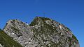
 East view |
||
| height | 2268 m above sea level NHN | |
| location | Bavaria , Germany | |
| Mountains | Thumb group , Allgäu Alps | |
| Dominance | 1.6 km → Großer Wilder | |
| Notch height | 261 m ↓ Himmelecksattel | |
| Coordinates | 47 ° 23 '0 " N , 10 ° 23' 0" E | |
|
||
| First ascent | O. Sendtner around 1850 | |
| Normal way | South ridge from Himmelecksattel ( I ) | |

The Schneck is a 2268 m high grass mountain in the Allgäu Alps . Because of its peculiar shape, it is (like the Höfats ) unique in the Northern Limestone Alps. It forms the natural continuation of the massif which strikes northeast from the Höfats and is interrupted by a depression in the rearmost Oytal, and has a similar abundance of flowers to the Höfats. Seen from the Oytal, it forms the end of the valley floor.
Ascent
The actual summit is preceded by the Himmeleck as a grassy pre-summit , which is also easily accessible for hikers from the path over the Himmelecksattel. The transition to the main summit is very exposed over a rocky edge (difficulty: I ). According to tradition, the hunter Thaddäus Blatter is said to have carried the summit cross upright over the rocky edge in the 19th century.
Climb
The north face, which breaks off vertically to the north, was climbed for the first time in 1902 by H. Demeter and companions . The west wall was walked on in 1904 by W. Herz and H. Haug . The partially overhanging east face (VI-, A0) has long been considered the most difficult climbing tour in the Allgäu Alps. Up until 1946, following its first ascent by Risch in 1922, the tour had been repeated once (1936 by Ignaz Vogler and Otto Niederacher ). In 1947 Anderl Heckmair assessed the route through the Schneck east face to be more difficult than the north face of the Große Zinne . In 1949 he succeeded the third ascent of the wall.
The grass ridge, which stretches to the southwest, falls very steeply after the Himmelhorn into the Oytal and is also an extremely difficult, notorious grass climb ( Rädlergrat ).
photos

East flank

West flank

Summit cross
Key point


literature
- Stefan Meineke: Allgäu climbing guide , Leipzig, Mountain Explorer in the Academic Publishing House (AVA), 1998, ISBN 3-931982-08-4
- Anton Spiehler : In development of the Eastern Alps , p. 84, Berlin 1893
- Thaddäus Steiner : Allgäuer Bergnames , Lindenberg, Kunstverlag Josef Fink, 2007, ISBN 978-3-89870-389-5
- Thaddäus Steiner: The field names of the municipality of Oberstdorf im Allgäu , Munich, self-published by the Association for Field Name Research in Bavaria, 1972
- Zettler / Groth: Alpine Club Guide Allgäu Alps . Munich, Bergverlag Rudolf Rother 1984. ISBN 3-7633-1111-4
Web links
Individual evidence
- ^ Ernst Zettler: Allgäu Alps ; 5th edition 1949 revised by Heinz Groth. Bergverlag Rudolf Rother , pp. 192–195.
- ^ Anderl Heckmair: Bergsteiger Jahrbuch 1949, p. 80.
- ^ Robert Jaspers: Allgäu climbing guide , Akademische Verlagsanstalt Leipzig 1998, p. 284.