Sky horn
| Sky horn | ||
|---|---|---|
|
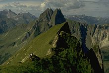
Himmelhorn with its south face, the Rädlergrat and Schneck summit (2259 m) |
||
| height | 2111 m above sea level NHN | |
| location | Bavaria , Germany | |
| Mountains | Thumb group , Allgäu Alps | |
| Dominance | 0.1 km → Schneck | |
| Notch height | 31 m ↓ notch to the snail | |
| Coordinates | 47 ° 22 '55 " N , 10 ° 22' 34" E | |
|
|
||
| First ascent | by locals | |


The Himmelhorn is a 2111 meter high mountain peak in the Allgäu Alps .
Location and surroundings
It is not an independent summit, but only a culmination point of the grass ridge that stretches from the snail to the south-southwest, where the ridge forks and falls into the Oytal in extremely steep grass and rock flanks .
The notch height of the Himmelhorn is at least 31 meters, its dominance 100 meters, whereby the Schneck is the reference mountain in each case.
botany
The botany of the Himmelhorn is as rich as that of Höfats or Schneck.
Climbs
The Himmelhorn became famous for climbing the Rädlergrat in 1910. There is no marked path to the Himmelhorn. All climbs are more or less difficult grass climbs and require very good climbing experience, surefootedness and a head for heights . The more difficult climbs on the Himmelhorn are among the most demanding and dangerous grass climbs in the Allgäu Alps.
From the Himmelecksattel
- Difficulty : II
- Time required: 3/4 hours
- Starting point: Himmelecksattel
- First climber: unknown
- Note: grass and crag climbing, sometimes very exposed, poor security options
From the snail pre-summit
- Difficulty: II
- Time required: 3/4 hours
- Starting point: Schneck pre-summit
- First climber: unknown
- Note: grass and crag climbing, sometimes very exposed, especially the descent through the 70 ° steep grass flank to the high passages , poor security options
West wall
- Difficulty: VI
- Time required: 4½ hours
- Starting point: Laufbach valley
- First rider: Faschingleitner, Zint, 1932
- Note: hardly used any more
South wall
- Difficulty: VI, A2, A3
- Time required: 3–5 hours
- Starting point: Stuibenfall
- First climbers: M. Tauscher, W. Teufele, 1958
South face, "Sky Ride"
- Difficulty: IX or VII / A1
- Starting point: Stuibenfall
- First climbers: Matthias Robl and Alexandra Plattner , 2000
Rädlergrat
The Rädlergrat, a (grass) climbing tour , leads from the Stuibenfall in the rear Oytal near Oberstdorf over the southwest ridge to the Himmelhorn. It was first climbed alone in 1910 by the teacher Hermann Rädler from Langenwang. His route led in the last, upper part through an extremely unreliable, crumbling grass and rock wall on the flatter part of the ridge and on to the summit of the Himmelhorn. In this 20-meter climbing route ( difficulty V + ) there is practically no possibility of securing, so there have been numerous fatal falls in the past, for example the fatal fall of a rope team of three brothers from Oberstdorf in 1956.
Due to the numerous accidents, the original route is no longer used today, instead the technically more difficult but somewhat safer variant, which leads through the vertical, uppermost (westernmost) area of the Himmelhorn south face (difficulty VI- , A2). Nonetheless, the Rädlergrat remains a company that should not be underestimated, and in the middle of the 20th century it also inspired well-known rock climbers such as Gaston Rébuffat , also because of the not to be underestimated approach over steep, grass-strewn rock faces at the beginning of the former Gaisbachtobelweg. Due to the combination of brittle rock passages with very steep grass flanks (as with the Höfats ), the Rädlergrat is a challenge even for very good climbers.
The Rädlergrat owes its nimbus not only to the dangerousness and technical difficulties, but also to the botanical beauties that this ascent is home to. Nowadays the Rädlergrat is climbed an average of two to three times a year.
The sky horn in literature
Himmelhorn is the title of the ninth crime novel about the Allgäu commissioner Kluftinger by the German writers Michael Kobr and Volker Klüpfel , published in 2016 . In this fictional case, Kluftinger is investigating an alleged mountain accident in which three mountaineers were killed on the Rädlergrat.
literature
- Stefan Meineke, Robert Jasper: Allgäu climbing guide . Mountain Explorer in the Academic Publishing House (AVA), Leipzig 1998, ISBN 3-931982-08-4 .
- Thaddäus Steiner : Allgäu mountain names . Kunstverlag Josef Fink, Lindenberg 2007, ISBN 978-3-89870-389-5 .
- Thaddäus Steiner: The field names of the municipality of Oberstdorf im Allgäu , Munich, self-published by the Association for Field Name Research in Bavaria, 1972
- Ernst Zettler, Heinz Groth: AVF Allgäu Alps . Bergverlag Rudolf Rother, Munich 1984, ISBN 3-7633-1111-4 .
- Bergecho , Oct. 1970
- Bergkamerad , Aug. 1972
- The beautiful Allgäu , 1954, p. 76
Web links
Notes and individual references
- ↑ Exact value not known, stated value is a minimum value (can be up to 19 meters higher). It was determined from the distance between the contour lines (20 meters in altitude ) on a topographic map ( scale 1: 25,000).
- ↑ Allgäu climbing history ( memento of the original from October 20, 2012 in the Internet Archive ) Info: The archive link was automatically inserted and not yet checked. Please check the original and archive link according to the instructions and then remove this notice. . Retrieved November 14, 2012.
- ↑ Droemer-Knaur publishing group: Himmelhorn. Kluftinger's new case. Retrieved December 3, 2016 .


