
Schneckenstein (Tannenbergsthal)
|
Snail stone
Community Muldenhammer
Coordinates: 50 ° 24 ′ 49 ″ N , 12 ° 26 ′ 41 ″ E
|
||
|---|---|---|
| Height : | 860 m | |
| Postal code : | 08262 | |
| Area code : | 037465 | |
Location of Schneckenstein in Saxony |
||
 Settlement plan around 1960
|
||

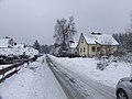
Schneckenstein is a district of Tannenbergsthal in the Vogtland community of Muldenhammer in Saxony . The place is located about 500 meters west of the Schneckenstein rock at an altitude of about 860 meters. The settlement was built between 1948/49 and 1953 by SAG Wismut and consisted of four Viennese houses as mass accommodation in the north, two- and three-story multi-family houses in typical unitary construction in the center, and single-family houses (Berlin houses) in the south. In 1968 the settlement was incorporated as a district after Tannenbergsthal. After the end of uranium mining on the Schneckenstein, the buildings in the north were used as a school camp and for the pre-military training of the GST . Today these buildings are partly empty. During the GDR times, there was a vacation home of VEB Industriewerke Karl-Marx-Stadt in Schneckenstein .
From 1958 to 1991, the DHFK Leipzig winter sports center was located southwest of the settlement on the site of shaft 241 (Schneckenstein shaft ) . This also used the dumps contoured for it as downhill slopes. The mine buildings, which were still used by the DHFK, were demolished after the turn of the millennium, with the exception of the former cafeteria below the heaps. The latter still serves as a clubhouse for the Auerbach shooting club.
Tourist attractions include the visitor's mine Grube Tannenberg , the Vogtland region Bohemian mineral center and the worm rock.

Schneckenstein plateau with settlement

"Wiener Haus" in the north

"Apartment blocks" in the town center

"Berlin houses" in the south
Holzhäuserstraße in the south


Web links
- Schneckenstein in the Digital Historical Directory of Saxony
Individual evidence
- ↑ Lehmann, Kalb u. a. (Ed.): German University for Physical Culture Leipzig 1950-1990 . Aachen: Meyer & Meyer 2007, ISBN 978-3-89899-286-2 , p. 356.
- ^ Shooting Society Auerbach / V. eV

Gottesberg | Hammer Bridge | Hunter green | Morgenröthe-Rautenkranz (with Morgenröthe and Rautenkranz) | Sachsengrund | Snail stone | Tannenbergsthal