Schussental

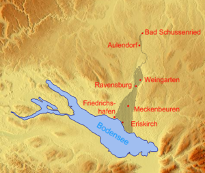
The Schussental in the Bodensee-Oberschwaben region extends from the source of the small river Schussen north of Bad Schussenried to the mouth of the river south of Eriskirch in the area of the Eriskircher Ried in Lake Constance .
Narrower and wider term
The Schussental includes both the wider basin and the Schussentobel. The basin narrows from the direction of Lake Constance near Ravensburg and widens slightly north of Weingarten until it merges into the narrow Schussen tobel at Mochenwangen . Colloquially, only the middle Schussental is often referred to as this (see also the naming of the community administration association Mittleres Schussental ).
landscape
The Schussentobel is comparatively close to nature and cuts through, among other things, the Altdorf Forest . This northern part of the Schussental is in contrast to the agglomeration of the central Schussental with the cities of Ravensburg , Weingarten and the communities of Berg , Baienfurt and Baindt . The southern part is used extensively for the cultivation of fruit and, mainly in the Tettnang area , for the cultivation of hops . The Eriskircher Ried forms the transition to Lake Constance.
Emergence
Contrary to what the name suggests, the valley was not formed by the Schussen river, but by an ice age glacier tongue . The Schussen only dug their way from the source through a prefabricated river bed southwards to Lake Constance.
See also
- Schussenbecken and Schmalegger Tobel protected area
Web links
Coordinates: 47 ° 48 ′ 40.7 " N , 9 ° 36 ′ 51.9" E

