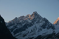
Schwabenkopf
| Schwabenkopf | ||
|---|---|---|
|
The Schwabenkopf from the Verpeiltal |
||
| height | 3378 m above sea level A. | |
| location | Tyrol , Austria | |
| Mountains | Ötztal Alps | |
| Dominance | 0.85 km → Verpeilspitze | |
| Notch height | 182 m ↓ Schwabenjoch | |
| Coordinates | 47 ° 0 '24 " N , 10 ° 47' 37" E | |
|
|
||
| First ascent | August 6, 1892 by Theodor Petersen , led by Johann Praxmarer and Johann Penz | |
The Schwabenkopf is 3378 m above sea level. A. high mountain in the Kaunergrat in the Ötztal Alps , which breaks off with a mighty, 1000 m high flank into the Verpeiltal.
The first ascent of the summit took place in 1892 by Theodor Petersen with the Kaunertal mountain guides Johann Praxmarer and Johann Penz. The Verpeilhütte and the Kaunergrathütte are nearby .
The name is probably associated with the children of the Kauner and Pitztal valleys, who used to be loaned out to Swabia every summer as agricultural workers.
Individual references and sources
- ↑ Clem Clements, Jonathan de Ferranti, Eberhard Jurgalski , Mark Trengove: The 3000 m SUMMITS of AUSTRIA - 242 peaks with at least 150 m of prominence , October 2011, p. 8. Height of the reference chart according to: Walter Klier: Alpenvereinsführer Ötztaler Alpen, Munich 2006, RZ 1503.
- ↑ Federal Office for Metrology and Surveying Austria: Schwabenkopf on the Austrian Map online (Austrian map 1: 50,000) .
- ^ Walter Klier : Alpine Club Guide Ötztal Alps . Bergverlag Rudolf Rother . Munich 1993. ISBN 3-7633-1116-5


