Black Mountain (Eschweiler)

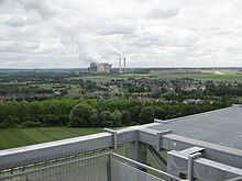
The Black Mountain is about 50 meters high, with predominantly birch -covered heap in Eschweiler city forest in the Aachen region . On his in 250.1 m above sea level. NN lying tip there is a wooden cross and a lookout point, from which one has a good view to the east over the Eschweiler city center and the districts of Bergrath , Hastenrath and Weisweiler . Its base is around 20 hectares . About 120 steps lead up to its summit and it is a landmark of Eschweiler mining . There is a refuge at the foot of the stairs.
history
At the foot of Black Mountain, the well was Henry Schacht called Kunstschacht . This for dewatering used bay of the former pit center of the Eschweiler mine association EBV was 1857-1891 in operation. In 1857, after ten years of construction, the engine house of the shaft was completed with a 1600 HP and 1300 HP steam engine with 18 steam boilers and the deepest floor was reached with the water art at 362.66 meters. The building was rebuilt after it was closed and was used for residential purposes until it was demolished in mid-1970.
About the ravine "dog canal", which today nearly-south direction Northern in through the fields between Röthgen runs and Bergrath, led from 1888 until the Second World War, a cable car from the pit reserve at Nothberg to Concordia Hut at Ichenberg . The overburden to the Black Mountain was tipped up with this cable car .
Kitzberg
To the west of the Black Mountain is the significantly lower and elongated Kitzberg. The Kitzberg is also a mining dump. It was poured in during the operation of the "Kronprinzenschacht" from 1840 to 1883. "Kitzberg" means "pointed mountain".
literature
Engelbert Zander: Hundsgracht and Hundsbenden. In: Series of publications by the Eschweiler history association . Vol. 11, Eschweiler 1989, pp. 24-28.
Coordinates: 50 ° 48 ' N , 6 ° 16' E

