
Schweikert (Kaunertal)
| Schweikert | ||
|---|---|---|
 Schweikert (left, dark) from the Langetsbergalm with a full moon and 20 seconds exposure |
||
| height | 2879 m above sea level A. | |
| location | Tyrol , Austria | |
| Mountains | Kaunergrat , Ötztal Alps | |
| Dominance | 0.56 km → Hochrinnegg | |
| Notch height | 61 m ↓ Scharte to Hochrinnegg | |
| Coordinates | 47 ° 2 '0 " N , 10 ° 46' 25" E | |
|
||
| Normal way | From the Verpeilhütte in approx. 2-3 hours over the southeast ridge (I) | |
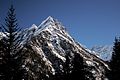
 View from Kaunertal to the summit, west side |
||

The Schweikert is a 2879 m (according to other information 2881 m ) high mountain in the Kaunergrat in the Ötztal Alps , in the Austrian state of Tyrol . It is the second highest point in the Hochrinnegg massif ( double peaks with 3067 and 3027 m ). Due to its easy accessibility from the Verpeilhütte , it is a popular tour destination. The first documented first tourist ascent was made in 1893 by S. Simon.
Location and surroundings
The Schweikert is located in the east-west ridge of the Hochrinnegg massif , a mountain group north of the Verpeiltal , a side valley branching off east of the Kaunertal. The neighboring mountain in the east is the Hochrinnegg with its double summit. To the north, the Schweikert falls into the Gsalltal , to the south into the Verpeiltal and to the west into the Kaunertal. The closest permanently settled place is Feichten in the Kaunertal , which is about two kilometers as the crow flies in a west-southwest direction.
Tourist development
As a base for an ascent of Schweikert on 2,025 meters of altitude is east of Feichten in Verpeiltal lying Verpeilhütte, from which the top in about 2½ hours walking in some heavily exposed hike in difficulty UIAA I can be reached. There are climbing routes of difficulty UIAA III to IV on the northwest ridge . A drilled sport climbing route named Wiesa Jaggl , with 12 pitches and key points in the UIAA level VII, was opened by Florian Schranz and Matthias Ragg of 2004.
Impressions
Schweikert in winter

Schweikert and neighboring summit


Literature and map
- Walter Klier : Alpine Association Guide Ötztaler Alpen , Bergverlag Rother , Munich, 14th edition 2006, ISBN 3-7633-1123-8
- Alpine Club Map 1: 25,000, sheet 30/3, Kaunergrat
Individual evidence
- ^ Austrian Map online 1: 50,000 (ÖK 50) of the BEV
- ↑ a b Walter Klier : Alpine Guidebook Oetztal Alps . Bergverlag Rother . Munich 1993. ISBN 3-7633-1116-5
Web links
- Sports climbing route "Wiesa Jaggl" (PDF file; 144 kB)