Schwende (Dornbirn)


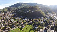
Schwende is between about 750 m above sea level. A. and 1100 m above sea level A. lying, in a slight curve from north to west sloping plot with historical roots back to the Middle Ages in the municipality of Dornbirn .
Name derivation
Schwenden refers to clearing by burning down trees and bushes in order to gain new usable land. (see also Schwendbau ). As a place name, Schwende occurs alone and in many word components in Vorarlberg.
location
The plot is about 2.5 km as the crow flies from the city center ( 437 m above sea level ). At the lower western edge is the Rotte Schwendebach , at the upper northern edge the plot is bounded by the Fallenberg forests.
economy
The alpine economy, which had dominated this area for a long time, is becoming less and less important and the large pastures are slowly growing over again. The Alpe Schwende 911 m above sea level. A. was sold to the Counts of Hohenems in 1409 and is now part of an agricultural community . In 2013, part of the alpine building was renewed (loose barn for dairy cows) and a photovoltaic system with a 22.5 kWp bottleneck output was installed.
The forestry was at times an important part of the management of the plot and the adjoining forests. The wood was partly brought in via giants (wooden slides). The district of Watzenegg , Unterries ( 668 m above sea level ), located to the west below the Schwende plot , and several field names on the Schwende itself, such as Ries , Holzries or Riesbrunnen or Hohlegass , still indicate this today . Today the forest is managed with heavy trucks on forest roads .
A project planned in the early 1950s for a lift connection via the Schwende to Bödele by the Dornbirner Seilbahngesellschaft (see: Karrenseilbahn ) was not implemented. For many years the Schwende was a popular descent for experienced skiers from the Oberlose / Lank into the valley to Dornbirn.
Traffic routes
From time immemorial, a mule track led across the Schwende from the Bregenzerwald over the Bödele to Dornbirn. The necessary preservation was always a topic in the old Dornbirn council minutes. Another, similar mule track led from Haselstauden via Ammenegg and the Losenpass into the Bregenzerwald. This mule track over the Schwende, now a partially developed goods route , branches off between Schwendebach and Schauner and in some parts still follows the old route.
In the event of cattle epidemics in the Bregenzerwald, guards were set up at the Losenpass and the Schwende (see field name: Schwendgatter ) so that no cattle could be brought to Dornbirn.
Waters
In the Schwende parcel, several relevant streams arise at the edges (e.g. Simonsgraben, Eisenharzgraben), which drain south and west into the Dornbirnerach and then into Lake Constance .
Web links
Individual evidence
- ↑ Dornbirn Lexicon ( Memento of the original from March 4, 2016 in the Internet Archive ) Info: The archive link was inserted automatically and has not yet been checked. Please check the original and archive link according to the instructions and then remove this notice. , Search word: "Schwendebach, III."
- ↑ Dornbirn Lexikon ( Memento of the original from July 13, 2016 in the Internet Archive ) Info: The archive link was inserted automatically and has not yet been checked. Please check the original and archive link according to the instructions and then remove this notice. , Keyword: "Unterries".
- ↑ Unser Ländle ( Memento of the original from March 4, 2016 in the Internet Archive ) Info: The archive link was inserted automatically and has not yet been checked. Please check the original and archive link according to the instructions and then remove this notice. , Announcements from the Chamber of Agriculture Vorarlberg, p. 6.
- ↑ Dornbirn Lexicon ( Memento of the original from March 9, 2016 in the Internet Archive ) Info: The archive link was inserted automatically and has not yet been checked. Please check the original and archive link according to the instructions and then remove this notice. , Search term: "Schwende 966 m above sea level"
- ↑ See e.g. E.g .: Council Book 1684-1736 , entry for May 27, 1718.
- ↑ See e.g. E.g .: Council Book 1684-1736 , entry for October 1693.
Coordinates: 47 ° 24 ′ 52.1 " N , 9 ° 46 ′ 33.7" E

