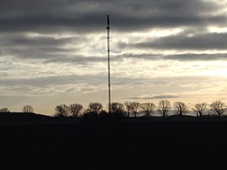
Nierstein transmitter
|
Nierstein transmitter
|
||
|---|---|---|
| Basic data | ||
| Place: | Geinsheim am Rhein ( Trebur ) | |
| Country: | Hesse | |
| Country: | Germany | |
| Altitude : | 85 m above sea level NHN | |
| Coordinates: 49 ° 52 ′ 11.4 " N , 8 ° 23 ′ 1" E | ||
| Use: | Broadcasting station | |
| Owner : | Südwestrundfunk | |
| Mast data | ||
| Construction time : | 1981 | |
| Building material : | steel | |
| Total height : | 138 m | |
| Data on the transmission system | ||
| Waveband : | FM transmitter | |
| Radio : | VHF broadcasting | |
| Position map | ||
|
|
||
The transmitter Nierstein is a transmitter of the Südwestrundfunk (formerly the Südwestfunk ) for broadcasting radio signals.
The transmitter is located on the Hessian side of the Rhine, southwest of the town of Geinsheim am Rhein . This location in a different federal state was chosen because the area to be supplied, the places Nierstein and Oppenheim , is partly in a shaded valley due to the steep slope of the Rote Hang and can therefore only be supplied sensibly from the opposite side of the Rhine. A 138 meter high guyed steel truss mast with a triangular cross-section is used as the antenna carrier. This was built in 1981 after it was previously used as part of the Lake Constance transmitter and dismantled there in the 1970s.
Frequencies and Programs
Analog radio (VHF)
|
Frequency (MHz) |
program | RDS PS | RDS PI | Regionalization |
ERP (kW) |
Antenna pattern round (ND) / directional (D) |
Polarization horizontal (H) / vertical (V) |
|---|---|---|---|---|---|---|---|
| 92.9 | SWR4 Rhineland-Palatinate | SWR4_MZ_ | DAA4 | Mainz | 0.1 | D (200-340 °) | H |
| 98.4 | THE THING | THE THING_ | D3A5 | - | 0.25 | D (200-270 °) | H |
Analog television (PAL)
Before the switch to DVB-T, the broadcasting location was still used for analog television:
| channel |
Frequency (MHz) |
program |
ERP (kW) |
Transmission diagram round (ND) / directional (D) |
Polarization horizontal (H) / vertical (V) |
|---|---|---|---|---|---|
| 40 | 623.25 | SWR television Rhineland-Palatinate | 0.035 | D. | V |
| 57 | 759.25 | The First (SWR) | 0.035 | D. | V |


