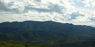
Serra del Montsià
| Serra del Montsià | ||
|---|---|---|
|
Central region of the Serra del Montsià, seen from the west |
||
| Highest peak | La Torreta ( 764 msnm ) | |
|
|
||
| Coordinates | 40 ° 37 ' N , 0 ° 33' E | |
| Type | Karst | |
| rock | limestone | |
| Age of the rock | 25 million years | |
The Serra del Montsià ( Catalan 'Mountain Range of Monstsià'; Spanish : Sierra Montsiá ) is a small, almost 15 kilometers long and up to 5 kilometers wide low mountain range , namesake of the Spanish comarca Montsià , the southernmost comarca of the autonomous region of Catalonia .
geography
The mountain range, about 2 to 5 kilometers from the coast of the Mediterranean , extends from north-northeast to south-southwest from the Ebro to the Riu de la Sénia . Its highest point is approximately in the middle of La Torreta with 764 meters.
The mountains of the Sierra are covered with maquis , olive , almond and carob trees grow on the lower slopes . On the south-eastern slope there is a large limestone quarry , which with its mining conditions has led to significant soil degradation . The mountains are interspersed with former cliffs , steep slopes and erosion channels, which makes them inaccessible in some areas.
There are some relics from the Iberian era on the hills of the chain . The small settlement of La Selleta on a hill at the foot of the Serra del Montsià above the orange plantations of Alcanar was established by Germans in the second half of the 20th century.
geology
The Serra del Montsià is a karst formation with a number of narrow passages and caves. Despite its proximity to the sea, it is part of the Catalan Serralada Litoral Catalana and was formed 25 million years ago as part of the Alpidian orogeny .
Its highest point, La Torreta del Montsià , rises to 764 meters; however, the Mola cima peak looks like the highest with its triangular profile from the Ulldecona area on the road from Barcelona to Valencia .
Other significant elevations are La Foradada , north of La Torreta , with a good view over the Ebro Delta , and the rocky Mata-redona .
Geologically, the section of the parallel mountain ranges Serra del Montsià - Ulldecona / Freginals Valley - Serra de Godall forms a transition from the Catalan-Mediterranean system to the Iberian Mountains .
Web links
Individual evidence
- ↑ Tagesspiegel online: Obituary Theodor Eichheim
- ↑ La Selleta - a German village in Spain . Baumeister, Munich 1977.
- ↑ Speleological investigations (PDF; 1.4 MB)
- ↑ Gepec.org: Serra del Montsià ( Memento of the original of July 26, 2011 in the Internet Archive ) Info: The archive link has been inserted automatically and has not yet been checked. Please check the original and archive link according to the instructions and then remove this notice.


