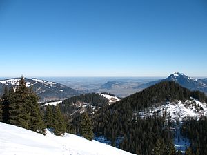
Sigiswanger Horn
| Sigiswanger Horn | ||
|---|---|---|
|
The Sigiswanger Horn on the right presents itself as a head wooded up to the summit. Immediately behind it the Grünten , to the left of the Sigiswanger Horn the 121 m lower Ofterschwanger Horn (center). |
||
| height | 1527 m above sea level NHN | |
| location | Bavaria , Germany | |
| Mountains | Pre-Alps west of the Iller , Allgäu Alps | |
| Coordinates | 47 ° 29 '5 " N , 10 ° 12' 34" E | |
|
|
||
| rock | Flysch | |
| First ascent | by locals | |
| particularities | Allgäu panoramic mountain in the horn group | |
The Sigiswanger Horn (also Sigiswangerhorn ) belongs to the horn group in the Allgäu Alps . It reaches a height of 1527 m and stands between Bolsterlang and Ofterschwang . Geologically, the Sigiswanger Horn, like the neighboring Rangiswanger Horn, belongs to the Flysch Mountains of the "Vorderen Hörnergruppe", which are rich in boggy meadows and species-rich canyon forest tobels.
description
The Sigiswanger Horn is "a head that is barely noticed and covered by forest". The summit of this horn can be climbed in a few minutes from the panorama path on the so-called Allgäuer Hörnertour , which runs between the Ofterschwanger Horn and the Weiherkopf . The summit of the Sigiswanger Horn is only adorned by a mossy pile of stones. This summit is - coming from the north - the second of four on the Hörnertour. The Hörnertour is a route that is taken both in summer and in winter (e.g. with snowshoes ). In winter, however, the route is neither marked nor signposted.
To the north of the Sigiswanger Horn is the Fahnengehrenalpe ( 1329 m ), to the east the Schwingundalpe ( 1078 m ) and the Kahlückenalpe ( 1189 m ), to the south the Sigiswangerhornalpe ( 1407 m ).
The name Sigiswanger Horn is named after the village Sigiswang , which lies at the eastern foot of the mountain. Sigiswang is a district of Ofterschwang. According to Thaddäus Steiner , the place name Sigiswang is formed in the first part from the old German personal name Sigi . In maps from the early 19th century, the spelling of the mountain is still Siegeswanger Horn .
Literature and maps
Hiking guide
- Sigiswangerhorn , in: Dieter Seibert, Allgäuer Alpen alpin , AV-Führer , Munich 2004, 16th edition, p. 145, ISBN 3763311262 .
cards
- Alpine Club Map Bavarian Alps, Allgäuer Voralpen West: Nagelfluhkette, Hörnergruppe, waymarking and ski routes, BY 1, 1st edition 2012, 1: 25,000, ed. from the German Alpine Club , ISBN 978-3-937530-41-3 .
- State Office for Surveying and Geoinformation Bavaria , UK L 8, Allgäu Alps , map of the area, scale 1: 50,000, Bavarian Surveying Administration, Munich, ISBN 3-86038-011-7 .
panorama
Individual evidence
- ↑ so Dieter Seibert, in: Allgäuer Alpen and Ammergauer Alpen. Alpine Club Guide, ed. by the German and Austrian Alpine Club, Bergverlag Rother, Munich 2004, 16th edition, ISBN 3-7633-1126-2 , p. 145
- ↑ so Thaddäus Steiner, Allgäuer Bergnames, Lindenberg 2007, p. 194, ISBN 978-3-89870-389-5


