Silberbach (Eger)
| Silberbach | ||
|
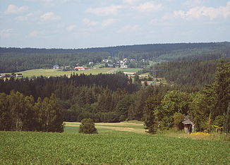
View from Neuhaus ad Eger over the Egertal to the Silberbachtal with the village of Silberbach |
||
| Data | ||
| location | District of Wunsiedel , Bavaria | |
| River system | Eger | |
| Drain over | Eger → Elbe → North Sea | |
| River basin district | Elbe | |
| source | Silberbrunnen on the Großer Hengstberg, Fichtelgebirge 50 ° 8 ′ 7 ″ N , 12 ° 11 ′ 12 ″ E |
|
| Source height | 565 m above sea level NN | |
| muzzle | at the Hirschsprung in the Eger Coordinates: 50 ° 7 ′ 21 ″ N , 12 ° 9 ′ 36 ″ E 50 ° 7 ′ 21 ″ N , 12 ° 9 ′ 36 ″ E |
|
| Mouth height | 525 m above sea level NN | |
| Height difference | 40 m | |
| Bottom slope | 20 ‰ | |
| length | 2 km | |
The Silberbach is a 2.7 kilometer long brook that names the scattered village Silberbach bei Selb , in the district of Wunsiedel , Bavaria .
course
The stream rises in the Silberbrunnen at the northern foot of the Großer Hengstberg in the Fichtelgebirge , flows through the village of Silberbach and flows into the Eger on the left opposite the Hirschsprungfelsen .
Surname
The name Silberbach is probably based on the 'cat silver', the leaching of mica from the local granite rock.
history
A first documentary mention was made in 1499 in the land register of the six offices on the occasion of a border description in the area of the Selber forest .
fauna
- Mainly spruce forest, old beech trees on the Großer Hengstberg.
- Nature reserves on the Hengstberg and the Eger.
literature
- Friedrich Wilhelm Singer : The land book of the six offices from 1499 ; District of Wunsiedel 1987
- Seidel, Gerhard: The nine judges' offices in the city administration and six offices in Wunsiedel 1673-1683 . 58th Report of the North Upper Franconian Association for Nature, History and Regional Studies eV , Hof 2010
- Saalfrank, Hans: At the silver fountain near Selb; in: Der Siebenstern 1950, p. 85
- Dietmar Herrmann, Helmut Süssmann: Fichtel Mountains, Bavarian Vogtland, Steinwald, Bayreuther Land. Lexicon . Ackermannverlag, Hof (Saale) 2000, ISBN 3-929364-18-2 .
