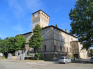
Sissa (Italy)
| Sissa | |||
|---|---|---|---|

|
|||
| Rocca dei Terzi (11th century) | |||
| Country | Italy | ||
| region | Emilia-Romagna | ||
| province | Parma (PR) | ||
| local community | Sissa Trecasali | ||
| Coordinates | 44 ° 58 ' N , 10 ° 16' E | ||
| height | 32 m slm | ||
| surface | 43.64 km² | ||
| Residents | 4,201 (Dec. 31, 2013) | ||
| Population density | 96 inhabitants / km² | ||
| patron | San Giacomo | ||
| Church day | July 25th | ||
| Telephone code | 0521 | CAP | 43018 |
Sissa ( Emilian : Sèsa ) is a fraction of the Italian municipality ( comune ) Sissa Trecasali in the province of Parma , Emilia-Romagna region .
geography
Sissa is located about 14 kilometers north-northwest of Parma at the confluence of the Taro and the Po at an altitude of 32 m slm on the orographic right side of the Taro.
history
1195 transferred Heinrich VI. the Church of Parma has jurisdiction over the parishes of Sissa , Palasone and Coltaro , today all districts of the parish of Sissa . Until 2013 the place was an independent municipality. On January 1, 2014, Sissa merged with Trecasali to form the new municipality of Sissa Trecasali. The municipality of Sissa had 4201 inhabitants on December 31, 2013 on an area of 42.9 km². The fractions Borghetta, Borgonovo, Casalfoschino, Coltaro, Gramignazzo, Palasone, San Nazzaro and Torricella belonged to it. Neighboring communities were Colorno , Gussola (CR), Martignana di Po (CR), Roccabianca , San Secondo Parmense and Torricella del Pizzo .
Web links
Individual evidence
- ↑ Sissa Trecasali, al via il nuovo Comune unico nel parmense. In: assemblea.emr.it. Retrieved November 27, 2019 (Italian).