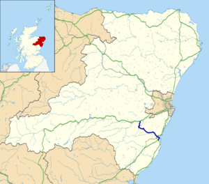
A957 road
| A957 road in the UK | |
| map | |
| Basic data | |
| Operator: | |
| Start of the street: |
Stonehaven ( 56 ° 57 ′ N , 2 ° 14 ′ W ) |
| End of street: |
Crathes ( 57 ° 4 ′ N , 2 ° 25 ′ W ) |
| Overall length: | 23.7 km (14.7 mi ) |
|
Course of the road
|
|
The A957 road is an A-road in the Scottish council area of Aberdeenshire . It is also known colloquially as Slug Road , which is likely derived from the Gaelic expression for a narrow pass or a gorge. The name could thus reflect the use of a narrow pass at a height of 230 m on the eastern foothills of the Cairngorms .
course
The road begins as a junction from the A92 ( Dunfermline - Stonehaven ) just before it joins the A90 . It initially leads in a north-easterly direction to the center of Stonehaven, where it forms one of the main roads. The A957 leaves Stonehaven in a north-westerly direction. A bridge spans the road over the A90 and it runs northwest through the sparsely populated regions of Aberdeenshire, where it connects the hamlets of Rickarton and Blairydryne . Before Rickarton the A957 crosses the Cowie Water and shortly before the junction with the A93 in Crathes the Dee . It has a total length of 23.7 km.
Individual evidence
- ↑ Directory of Gaelic expressions ( Memento of September 21, 2002 in the Internet Archive )
- ^ Entry in the Gazetteer for Scotland

