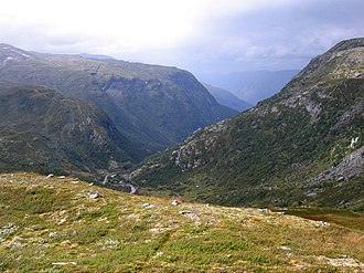
Sognefjellsveien
| Sognefjellsveien | |||
|---|---|---|---|
|
Sognefjellsveien |
|||
| Compass direction | west | east | |
| Pass height | 1434 moh. | ||
| Fylke | Vestland | Domestic | |
| Watershed | Sognefjord | Otta → Glomma | |
| Valley locations | Gaupne | Lom | |
| expansion | Reichsstrasse 55 | ||
| Built | 1936-1938 | ||
| Mountains | Jotunheimen | ||
| Map (Innlandet) | |||
|
|
|||
| Coordinates | 61 ° 34 '28 " N , 8 ° 2' 0" E | ||
The Sognefjellsvegen is the highest mountain pass in Northern Europe and connects as part of the National Highway 55, the two Norwegian places Gaupne and Lom . The highest point is at the Fantesteinen at 1434 m above sea level. The 110 km long road is one of the oldest transport links between Eastern and Western Norway .
The road has long been used as a trade route, transporting herring and other fish as well as salt from the coast to the inland and vice versa, hides, butter and iron from the inland to the sea. In earlier times, highwaymen made the area unsafe and robbed the transport of goods. This is where the name of the Fantesteinen (German: "Landstreicherstein") comes from .
After two years of renovation work carried out by unemployed young people, the road was opened to car traffic in July 1938.
In winter, Sognefjellsveien cannot be used due to the large amounts of snow and the prevailing storms. The winter closure lasts from the beginning of November to the beginning of May.

