Glomma
|
Glomma Glåma |
||
|
Course of the Glomma in Norway |
||
| Data | ||
| Water code | NO : 002.Z | |
| location | Trøndelag , Innlandet , Viken ( Norway ) | |
| River system | Glomma | |
| source | Near Tydal municipality 62 ° 51 ′ 32 ″ N , 11 ° 48 ′ 12 ″ E |
|
| Source height | 885 m | |
| muzzle | near Fredrikstad in the Oslofjord Coordinates: 59 ° 12 '11 " N , 10 ° 56' 57" E 59 ° 12 '11 " N , 10 ° 56' 57" E |
|
| Mouth height | 0 m | |
| Height difference | 885 m | |
| Bottom slope | 1.4 ‰ | |
| length | 621 km | |
| Catchment area | 41,965 km² (including 414.5 km² in Sweden) | |
| Discharge at the mouth of the A Eo : 41,965 km² |
MQ Mq |
698 m³ / s 16.6 l / (s km²) |
| Left tributaries | Renaelva , Flisa | |
| Right tributaries | Folla , Atna , Vorma (= Gudbrandsdalslågen ) | |
| Flowing lakes | Rien , Aursunden , Øyeren , Mingevannet | |
| Medium-sized cities | Sarpsborg , Fredrikstad | |
| Small towns | Elverum , Kongsvinger | |
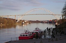
The Glomma (alternative spelling Glåma ) is the largest river in Scandinavia with an average water flow of almost 700 m³ / s and the longest river in Norway with a length of 601 kilometers .
The river has its source as Storelva in the central Norwegian municipality of Tydal and flows into the Oslofjord at Fredrikstad .
The catchment area of the Glomma covers around 13% of the area of Norway. There are numerous waterfalls in the course of the river , including the 23-meter-high fall in Europe, the Sarpsfossen . The river has many lake-like expansions and rapids. They gave rise to the construction of a number of power plants that together generate 10 percent of the energy from hydropower in Norway.
The river's rich fish population includes pike, perch, grayling, roach, trout and salmon.
There are many mostly uninhabited islands in the river; the largest inhabited islands are Tunøya as part of Sarpsborg and Rolvsøy as part of Fredrikstad. In the mid-1990s, the Sørumbåten dugout canoe was discovered in the river when the water level was low .
The 32 kilometer long Glommapfad ( Glommastien ) leads along both banks from Sarpsfossen to the old town ( Gamlebyen ) of Fredrikstad, including the house where Roald Amundsen was born in Borge.


