
Solgraben (USA)
|
Solgraben Sole ditch |
||
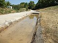
 The 20 ° C warm brine pours out of a bricked pirate treasure chest into the artificial watercourse |
||
| Data | ||
| Water code | DE : 24848792 | |
| location |
Hesse
|
|
| source | in Bad Nauheim 50 ° 21 ′ 53 ″ N , 8 ° 44 ′ 39 ″ E |
|
| Source height | approx. 147 m above sea level NN | |
| muzzle | in Bad Nauheim in the brine basin Coordinates: 50 ° 21 '33 " N , 8 ° 44' 49" E 50 ° 21 '33 " N , 8 ° 44' 49" E |
|
| Mouth height | approx. 146 m above sea level NN | |
| Height difference | approx. 1 m | |
| Bottom slope | approx. 1.3 ‰ | |
| length | 800 m | |
 Back of the artificially raised source with suspected technology in various inspection shafts |
||
The Solgraben even Sole ditch called, is a nearly one kilometer long artificial waterway in Bad Nauheim in Hesse Wetteraukreis , who from the north coming into the brine pool opens.
geography
course
The Solgraben begins at a height of about 147 m above sea level. NN in the spa area of Bad Nauheim at the intersection of Lindenstrasse and Zanderstrasse on an elevated terrace on the edge of a park around Gradierbau I (with inhalatorium). Its warm brine comes from Sprudel VII (also Great Sprudel , from 160 m depth with 30 ° C) and Sprudel XII (also Friedrich-Wilhelm-Sprudel , from 180 m depth with 33 ° C). It initially flows in an easterly direction along Lindenstrasse and after 75 m turns south-southeast on Goethestrasse , flows past Gradierbau I, crosses under Eleonorenring at the Solgraben bus stop and then runs past school facilities such as the Ernst Ludwig School and the Vocational School Schools at the graduation tower. It finally flows out at an altitude of about 146 m above sea level. NN from the northeast into the brine basin created around 1850 near Gradierbau III at Ludwigsbrunnen , where the brine can be further clarified and stored before it is spread.

It starts from a raised terrace at the park with the graduation building I.

The "upper course" of the Solgraben shortly after leaving its "source" (in the background)

The brine flows in the Solgraben from the north-northwest (in the back of the picture), left, in the west the Usa flows
The Solgraben comes from north-northeast (back) to the brine pool to

The Solgraben flows into the brine basin with a meter-deep fall into the basin

The overflow prevents the Solgraben at "full" salt water pool makes the brine flow into the landscape


character

The Bad Nauheimer Solgraben is an artificially created open canal to fill the brine basin with brine and to operate the graduation houses fed from it, which are called graduation buildings in Bad Nauheim . The brine comes from boreholes that were sunk in today's Sprudelhof in the 1840s after a light earthquake. Part of this brine was used for spa and bathing operations. Today it is led from the Sprudelhof in underground pipes to the "source" of the Solgraben. Its initially warm, rust-colored water is rich in salt and iron. Despite the physical and chemical conditions, plant and bacterial life exist in it, which rather forms colorless biofilms. Due to the continuous change in the physical and chemical conditions in the brine, dissolved minerals fall out over time in the form of white flake-like flakes and collect in places on the ground. Because of this and because the Solgraben absorbs fallen leaves, it has to be cleaned (desludged) again and again.
The brine ditch and the brine basin are technical facilities of the former Nauheim salt works. They have no connection to the USA , except that the brine basin can be drained via an underground channel to the USA opposite the Ludwigsbrunnen in the event of an impending overflow in order to prevent the uncontrolled drainage of brine from the ditch before it enters the basin. The brine basin cannot overflow because its edge is higher than the height of the mouth of the brine trench.
References and comments
- ↑ a b Google Earth
- ↑ Length measured on: Hessenviewer (Geoportal Hessen) of the Hessian State Office for Soil Management and Geoinformation with property mapping ( notes )
- ↑ Name on the property map of the Hessenviewer (scale finer than 1: 3.800)
- ↑ Graduation building I with inhalatorium
- ↑ eMail from the Magistrate of the City of Bad Nauheim, Department of Spa and Service Operations, 2018-08-08
- ↑ a b Information board at the Great Spring
- ^ Website of the vocational schools at the graduation tower
- ↑ Information board at the brine pool
- ^ Graduation building III at the Südpark
- ↑ Wind and water art at the Ludwigsbrunnen (and others)
- ^ History of the spa and industry in Bad Nauheim
- Jump up to 1960, transfer of ownership to the association 60 years later
Web links
- Hessenviewer (Geoportal Hessen) of the Hessian State Office for Soil Management and Geoinformation with property mapping ( notes )
- The Salz-Wanderweg , Wander-Bad-Nauheim.de ( Map: Der Salzweg )