
Thrush (Bach)
| thrush | ||
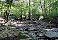
 The young thrush on the edge of the High Fens |
||
| Data | ||
| location | Belgium : Province of Liège | |
| River system | Rhine | |
| Drain over | Hill → Vesdre → Ourthe → Maas → Hollands Diep → North Sea | |
| River basin district | Meuse | |
| source | in the High Fens | |
| Source height | 620 m | |
| muzzle | at Eupen in the Hill coordinates: 50 ° 37 ′ 18 ″ N , 6 ° 2 ′ 21 ″ E 50 ° 37 ′ 18 ″ N , 6 ° 2 ′ 21 ″ E |
|
| Mouth height | 270 m | |
| Height difference | 350 m | |
| Bottom slope | 29 ‰ | |
| length | 12 km | |
The Thrush is a stream in Belgium that has its source in the High Fens and crosses the Hertogenwald . It flows into the Hill about 2 km south of Eupen at the place called "Black Bridge" .
Eupener Graben
In the 18th century, the Eupen cloth makers and tanners applied to the Habsburg governor in Brussels to dig a ditch to divert part of the water from the Gileppe stream into the thrush in order to reduce the production losses caused by the lack of water.
Thrush tunnel
From the beginning of the 1950s, an approximately 2.5 km long tunnel was built from the Thrush to the Gileppetalsperre, this time to protect Eupen from floods and to better serve the increased demand for drinking and service water in the Verviers area . During the construction work, a sudden severe storm led to a sharp rise in the water level. Eight workers were killed when the tunnel was flooded.
Individual evidence
- ↑ Tragedy of the thrush on July 6, 1952 ( page no longer available , search in web archives ) Info: The link was automatically marked as defective. Please check the link according to the instructions and then remove this notice.
Web links
Confluence of the Hill and Thrush (right)

Retention basin at the entrance to the thrush tunnel

Display board at the thrush reservoir

Memorial to the workers who died in the thrush tunnel


.jpg)