Sophien-Magdalenen-Koog
The Sophien-Magdalenen-Koog (also: Sophie-Magdalenen-Koog) is a Koog and part of the municipality of Reußenköge , Schleswig-Holstein . It was the first step towards the final dike in the Bredstedt Bay.
topography
The Sophien-Magdalenen-Koog is located on the eastern edge of the Reußenköge community on the approach road from Bredstedt (L 11). Neighboring crags are:
| Bordelumer Koog | Bredstedter Koog | |
| Reußenkoog |

|
Breklumer Koog |
| Cecilienkoog | Desmerciereskoog |
It is sparsely populated and is counted as part of the Jungmarschen due to the time it was dyed . The settlement structure largely corresponds to that of a scattered settlement . A coherent settlement structure is simply the row of former farm workers' houses along the so-called Schleusenweg.
history
Before colonization
After the two great mandrels of 1362 and 1634 , a sea gorge was created between the Hattstedter Marsch in the south and the island of Ockholm in the north, the so-called Bredstedter Bay. Under the name Bredstedter Werk , the Danish King Christian IV came up with the plan at the beginning of the 17th century to completely dike this bay. From Easter 1619, attempts were made for several years to complete this great work between the corner of Hattstedter Neuerkoog and Ockholm . After several storm surges in the years up to 1625, which repeatedly ruined the work, this plan was rejected for the time being.
The plan was only brought out again in 1708. Due to the previous experience, the king was no longer willing to carry out the dike himself. The tax money was too expensive for him. However, he was ready to issue an octroy for the damming of the lands. He did this in 1708. However, the owners of the Oktroy were more interested in a resale, which came about around 1711, than in the dike. Silting was initially promoted through the creation of thigh dykes in strategically favorable locations. And since you limited yourself to a smaller area for dike, this project could also be completed. However, the Christmas flood in 1717 and the ice flood in February 1718 destroyed this area, which roughly comprised the three crags Desmerciereskoog , Reußenkoog and Sophien-Magdalenen-Koog .
Final embankment
In 1728, Jean Henri Desmercières and his father, Count Gyldensteen, bought the Oktroy. The Koog was diked between 1741 and 1743 with a size of 608 hectares and named after the wife of the Danish King Christian VI , Queen Sophie Magdalene , born. Princess of Brandenburg-Bayreuth, named. In this context, a large-scale embankment including the Jakobshallig was dispensed with . The Bottergatt was also not dammed .
use
Agriculture
Today there are still six (originally eleven) farms in the Koog. Below is an organic farm . The farms generate their income through various branches of production. Agriculture with market crops is dominant here . In the meantime, photovoltaic systems can also be found on most of the roofs of the courtyards, which provide the business owners with additional income.
Community center
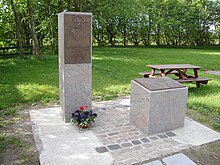
For the Reußenköge it forms the center of the community with the Koogshalle and the old school (today: among other things a meeting place for local associations). At this point, the builder of the Koog is also remembered with a plaque today.
Business
Ten wind turbines are in operation in Sophien-Magdalenen-Koog. These are assigned to three local community wind farms. In addition, the goods receiving department of a rural trading company has been located in Koog since 2009 . This commercial agricultural structure is supplemented by an agricultural engineering contractor .
Statistical data on the Koog
The table below shows the population and households from the census of May 25, 1987. Since then, these figures have only been updated at community level.
|
Residential space no. |
Koog | input deichung |
Area km² |
1987 census | ||||
|---|---|---|---|---|---|---|---|---|
| population | households | |||||||
| 6th | Sophien-Magdalenen-Koog 5 | 1741 | 6.19 | 77 | 25th | |||
| 5 Community center (not community administration, this is located outside the community in the east bordering town of Bredstedt ) | ||||||||
Web links
swell
- ↑ The Sophien-Magdalenen-Koog. on: reussenkoege.de
literature
- August Wilhelm Geerkens: Jean Henri Count Desmercieres. Flensburg 1960.
- Harry Kunz, Albert Panten: The Köge of North Frisia. Nordfriisk Instituut, Bredstedt 1997, ISBN 3-88007-251-5 , p. 41f.
- Nicolai Möllgaard: Sophie-Magdalenen-Koog 1741–1967. Desmerciereskoog 1767-1967. For the bicentenary of the Desmerciereskoog. Bredstedt 1967.
- Boy Chr. Sibbers: Koogsbook. Self-published, o. O. 2002.
Coordinates: 54 ° 35 ′ 52 ″ N , 8 ° 56 ′ 19 ″ E
