Souli (municipality)
|
Souli municipality Δήμος Σουλίου (Σούλι) |
||
|---|---|---|
|
|
||
| Basic data | ||
| State : |
|
|
| Region : | Epirus | |
| Regional District : | Thesprotia | |
| Geographic coordinates : | 39 ° 28 ′ N , 20 ° 31 ′ E | |
| Area : | 502.770 km² | |
| Residents : | 10,063 (2011) | |
| Population density : | 20 people / km² | |
| Seat: | Paramythia | |
| LAU-1 code no .: | 2002 | |
| Districts : | 3 municipal districts | |
| Local self-government : |
1 city district 31 local communities |
|
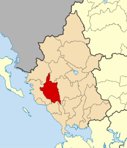
| Location in the Epirus region | ||
Souli ( Greek Σούλι ( n. Sg. )) Is a municipality in the Greek region of Epirus . The administrative seat of the municipality is the small town of Paramythia .
Administrative division
With the implementation of the administrative reform according to the Kallikratis program on January 1, 2011, the community of Souli was formed from the two communities of Paramythia , Acherondas and the rural communities of Souli . Since then, these have had parish status.
| Parish | Greek name | code | Area (km²) | 2001 residents | Residents 2011 | City district / local communities (Δημοτική / Τοπική Κοινότητα) |
location |
|---|---|---|---|---|---|---|---|
| Paramythia | Δημοτική Ενότητα Παραμυθίας | 200201 | 342.197 | 7859 | 7459 | Paramythia, Agia Kyriaki, Ambelia, Grika, Elataria , Zervochori, Kallithea, Karvounari, Karioti, Krystallopigi, Neochori , Xirolofos, Pangrates, Pende Ekklisies, Petousi, Petrvitsa, Plakoti, Polydroso, Prodromi, Chrysakays., Servavastgio | |
| Acherondas | Δημοτική Ενότητα Αχέροντα | 200202 | 67,343 | 2344 | 2146 | Gardiki, Glyki, Scandalo, Choika | |
| Souli | Δημοτική Ενότητα Σουλίου | 200203 | 93.230 | 748 | 458 | Avlotopos, Koukoulii, Samonida, Tsangari, Frosyni | |
| total | 2002 | 502.770 | 10,951 | 10,063 | |||
Individual evidence
- ↑ Results of the 2011 census at the National Statistical Service of Greece (ΕΛ.ΣΤΑΤ) ( Memento from June 27, 2015 in the Internet Archive ) (Excel document, 2.6 MB)


