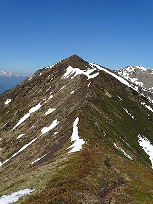
Speikkogel (Eisenerzer Alps)
| Speikkogel | ||
|---|---|---|
|
Speikkogel from Hinkareck |
||
| height | 1992 m above sea level A. | |
| location | Styria , Austria | |
| Mountains | Eisenerzer Alps | |
| Coordinates | 47 ° 29 '8 " N , 14 ° 41' 16" E | |
|
|
||
| rock | Blasseneck porphyroid | |
| Age of the rock | unclear (maybe Devonian , 400 million years old) | |
The Speikkogel is a 1992 m above sea level. A. high summit of the Eisenerzer Alps above the Schoberpass .
Location and landscape
The mountain is located between the forest on the Schober pass and Radmer . It is located in the main ridge of the Eisenerzer Alps, west of the Zeiritzkampel ( 2125 m above sea level ). It is separated from this by the saddle at the Antonikreuz (approx. 1880 m ), with the Hinkareck ( 1932 m above sea level ) rising in between . The saddle to this is 1870 m high. In the other direction, the ridge goes over the Seekartörl ( 1875 m above sea level ) to the Lahnerleitenspitze ( 2027 m above sea level ).
The Sulzbach , the tributary of the Liesing on the Schoberpass, flows southwards . The Palten rises to the southwest . To the north, below the Jakobsleiten in the Seekar, the Pfefferwinkelgraben goes as one of the headwaters to the Radmer Bach and Erzbach . The Liesing goes to the Mur , Palten and Erzbach to the Enns . This makes the summit part of the main watershed of the Alps .
The summit is on the municipal boundary of Wald am Schoberpass to Radmer bei Eisenerz (there is another Speikkogel ). The name refers to the (real) Speik ( Valeriana celtica ), a plant for a valuable fragrance that was traded in the Orient especially via Judenburg and Venice.
geology
The summit is formed from Blasseneck - porphyroid of the main ridge of the Eisenerzer Alps, which belongs to the Noric nappes of the Grauwackenzone . This formation is interpreted as the deposit of ash streams from an ancient volcanism; the date is unclear and is placed in the Devonian (around 400 million years ago).
Tours
The Eisenerzer-Alpen-Kammweg (No. 673) runs over the summit . The ascent on marked paths is via the Antonikreuz (from Wald or Radmer ) or the Leobner Törl ( 1739 m above sea level ) west of the Lahnerleitenspitze (from Vorwald or Wald, or from Johnsbach ).
Individual evidence
- ↑ a b Via Hinkareck, 1932 m, and Lahnerleitenspitze, 2027 m. Tour No. 31. In: Günter Auferbauer, Luise Auferbauer: Gesäuse: With the Eisenerzer Alps. Bergverlag Rother, 2015, ISBN 9783763342136 , p. 88 ff.
- ↑ Jörg Loeschke, Thomas Kretzschmar, Vera Langer, Martin Streck: On the geology of the Noric nappes northwest of Kalwang (Eisenerzer Alps, Steirische Grauwackenzone / Austria). In: Yearbook of the Federal Geological Institute , Volume 133 (1990), esp. 2.5. Blasseneck- "Porphyroid" , p. 352 f, whole article p. 345–363, PDF on ZOBODAT there p. 8 f.
- ↑ The Eisenerzer-Alpen-Kammweg. bergwelten.com - Tour description with map.

