Springfield (Oregon)
| Springfield | |
|---|---|
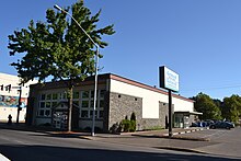
 Steps to City Hall and Springfield Library |
|
| Location in county and state | |
| Basic data | |
| Foundation : | 1848 |
| State : | United States |
| State : | Oregon |
| County : | Lane County |
| Coordinates : | 44 ° 3 ′ N , 123 ° 1 ′ W |
| Time zone : | Pacific ( UTC − 8 / −7 ) |
|
Inhabitants : - Metropolitan Area : |
59,403 (as of 2010) 270,000 |
| Population density : | 1,592.6 inhabitants per km 2 |
| Area : | 37.3 km 2 (approx. 14 mi 2 ) |
| Postcodes : | 97477, 97478, 97482 |
| Area code : | +1 (541) 682 |
| FIPS : | 41-69600 |
| GNIS ID : | 1127456 |
| Website : | www.springfield-or.gov |
| Mayor : | Christine Lundberg |
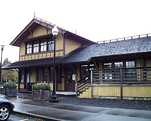
 Springfield Depot |
|
Springfield is a city in the west of the US state Oregon with 59,403 inhabitants (as of 2010). The city is located on Interstate 5 and forms a metropolitan area in Lane County with the neighboring city of Eugene .
General
The first residents of Springfield are members of a Briggs family who settled in the area in 1848. The settlement was declared a town in 1885 and named after a nearby spring. The lumber industry dominated Springfield for decades until the health industry discovered the city as a location in the early 1990s. The number of inhabitants has risen sharply within decades; In 1950, just under 11,000 people lived in Springfield; in 2010 it was almost 60,000.
Personalities
- Peter DeFazio (* 1947), politician, lives in Springfield
- Bill Dellinger (* 1934), athlete
- Ken Kesey (1935–2001), writer and artist
- Kip Kinkel (* 1982), gunman
- Eric Millegan (born 1974), actor
- Jimmy Patton (1931–1989), country and rockabilly musician
- Robert W. Straub (1920–2002), 31st Governor of the State of Oregon; died here
- Theodore Sturgeon (1918–1985), science fiction writer
Web links
Commons : Springfield (Oregon) - Collection of pictures, videos, and audio files

