
St. Cyprian
| St. Cyprian | |||
|---|---|---|---|
| Italian name : San Cipriano | |||
| Country | Italy | ||
| region | Trentino-South Tyrol | ||
| province | South Tyrol (BZ) | ||
| local community | Tiers | ||
| Coordinates | 46 ° 28 ' N , 11 ° 33' E | ||
| height | 1100 m slm | ||
| patron | Cyprian of Antioch | ||
| Church day | September 26th | ||
| Telephone code | 0471 | CAP | 39050 |
St. Zyprian ( Italian San Cipriano ) is a fraction of the municipality of Tiers in South Tyrol , Italy . It is located at 1100 m slm in the Tiers valley and is about 3 kilometers from the main town of the municipality.
The place is on the road to the Niger Pass ; the eponymous church is located just outside the village at the junction of the road to Weisslahnbad .
The bus line to Tiers ends in St. Zyprian (at the end of the village is the final stop Zyprianer Hof). Some of the buses continue to the Karer Pass .
Because of its proximity to the Rosengarten area , the Schlern-Rosengarten nature park begins right there, St. Zyprian is a popular starting point for hikes. The main source of income is tourism, there are only a few farmers left, the fields above the village are mainly cultivated by farmers from the main town.
church
Like the parish church of St. George in Tires, the Cyprian Church was built in the 13th century and is dedicated to Saints Cyprian and Justina of Antioch. It was renewed around 1538. West facade with a simple arched door and a clapboard roof. The tower is closed by a shingle-covered pyramid roof and is connected to the building to the northeast. It has its own entrance through a wooden ladder. The fresco on the southern outside with the depiction of the namesake, who protect the meadows of the village from storms, dates from the 17th century and shows clear signs of weathering and damage (March 2017).
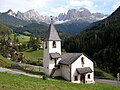
Cyprian church with rose garden

Inscription on the chapel


Individual evidence
- ↑ Entry in the monument browser on the website of the South Tyrolean Monuments Office
- ↑ http://rosengarten-latemargebiet.com/orte/126-st-zyprian.html
Web links
- St. Zyprian near South Tyrol