Districts of Aachen
The city districts of Aachen represent an administrative division of the city area of Aachen .
history
In earlier incorporations into the city of Aachen , the incorporated areas together with the previous city of Aachen formed a unified urban area, their former territory was only identifiable by the names of the districts of Aachen used for cadastral purposes . The last, on January 1, 1972, incorporation of seven surrounding communities in accordance with the Aachen Law of 1971 , the area of the Aachen city area grew to about three times, which made a new administrative subdivision necessary. For this purpose, the urban area was divided into seven districts .
Aachen-Mitte, the largest of the new city districts, corresponded, with minor exceptions, to the city area before 1972, i.e. including the earlier incorporations of Burtscheid and Forst . The five newly incorporated municipalities of Brand , Eilendorf , Haaren , Laurensberg and Richterich became separate city districts. The part of the municipality of Kornelimünster that was incorporated into Aachen and the former municipality of Walheim were combined with adjacent parts of the old urban area ( Sief , Lichtenbusch and an adjacent small area of forest) in the municipality of Kornelimünster / Walheim .
Townships
The seven districts of Aachen are (area and population as of December 31, 2016):
| Borough | Area (ha) |
Residents |
Density (inh./ha) |
|---|---|---|---|
| Aachen center | 5.163 | 164.904 | 31.9 |
| fire | 1,338 | 17,284 | 12.9 |
| Eilendorf | 684 | 15,708 | 23.0 |
| Hair | 880 | 12,564 | 14.3 |
| Kornelimünster / Walheim | 3,703 | 15,597 | 4.2 |
| Laurensberg | 2,997 | 19,879 | 6.6 |
| Richterich | 1,318 | 8,846 | 6.7 |
| Aachen as a whole | 16,083 | 254,782 | 15.8 |
Statistical districts
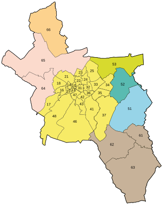
For statistical purposes, the seven city districts are partially subdivided into statistical districts , which are marked with a two-digit number (but not numbered continuously). There are 34 statistical districts in Aachen. Most of them (25) are in the Aachen-Mitte district.
| Borough | Statistical districts | |
|---|---|---|
| Aachen center |
10 Markt |
|
| fire | 51 fire | |
| Eilendorf | 52 Eilendorf | |
| Hair | 53 hairs | |
| Kornelimünster / Walheim | 61 Kornelimünster 62 Oberforstbach 63 Walheim |
|
| Laurensberg | 64 Vaalserquartier 65 Laurensberg |
|
| Richterich | 66 Richterich | |
Further subdivisions
For cadastral purposes , the urban area is divided into the districts of Aachen , some of which coincide with the city districts.
Regardless of the official city divisions in city districts, statistical districts and municipalities, there are numerous other place names for city districts and districts, localities and settlements that are generally considered to be districts of Aachen . These play a greater role in the spatial ideas of the population than the statistical districts.
See also
literature
- Julia Arndt, Friederike Henne, Myriam Moser, Benedikt Sonntag, Nick Wawroschek: Finally Aachen . rap publishing house, Freiburg im Breisgau 2014, ISBN 978-3-942733-15-1 , Where do you live ?, p. 6–43 ( Limited preview - boroughs with a brief description of their main districts).
Web links
- City districts on the official website of the city of Aachen
- City districts in the Aachen geoportal
- Statistical districts in the Aachen geoportal


