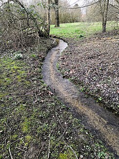
Steinsiekbach
| Steinsiekbach (Steinsieksbach) | ||
| Data | ||
| Water code | DE : 46396 | |
| location | North Rhine-Westphalia , Germany | |
| River system | Weser | |
| Drain over | Werre → Weser → North Sea | |
| source | In the Neustadt field Mark , Bad Salzuflen 52 ° 6 '31 " N , 8 ° 43' 43" O |
|
| Source height | approx. 156 m above sea level NN | |
| muzzle | In the Old Town Mark field in the Werre (KM26,1) coordinates: 52 ° 5 '55 " N , 8 ° 41' 29" O 52 ° 5 '55 " N , 8 ° 41' 29" O |
|
| Mouth height | approx. 68 m above sea level NN | |
| Height difference | approx. 88 m | |
| Bottom slope | approx. 26 ‰ | |
| length | 3.4 km | |
| Catchment area | approx. 2.1 km² | |
| Medium-sized cities | Herford | |
The Steinsiekbach , also Steinsieksbach , is a right, around 3.4 kilometers long tributary of the Werre in Herford in the northeast of the German state of North Rhine-Westphalia .
The water is part of the Weser river system and drains a small part of the Ravensberg hill country .
The Steinsieksbach, which rises above the zoo in the Salzufler Stadtforst in a washed-out Siek , got its name because of the many large boulders lying in the creek bed .
