Steintobelbach (Töss)
| Steintobelbach | ||
|
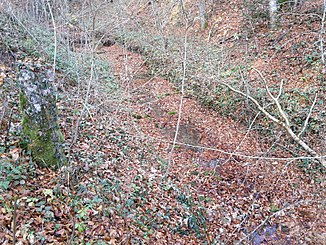
The brook in the Steintobel at the Kohlgrubenweg |
||
| Data | ||
| Water code | CH : ZH101302 | |
| location | Switzerland | |
| River system | Rhine | |
| Drain over | Töss → Rhine → North Sea | |
| Headwaters | in the Waldflur Isler am Eschenberg 47 ° 28 ′ 40 ″ N , 8 ° 44 ′ 26 ″ E |
|
| Source height | approx. 562 m above sea level M. | |
| muzzle | at Sennhof in the Töss coordinates: 47 ° 28 ′ 6 ″ N , 8 ° 45 ′ 10 ″ E ; CH1903: 699 063 / 258 351 47 ° 28 '6 " N , 8 ° 45' 10" O |
|
| Mouth height | 474 m above sea level M. | |
| Height difference | approx. 88 m | |
| Bottom slope | approx. 38 ‰ | |
| length | 2.3 km | |
| Catchment area | 1.21 km² | |
| Left tributaries | Eschenbergbach | |
| Right tributaries | Rietbächli, Burgstallbach, Juchertenbach | |
| Big cities | Winterthur | |
|
The stream at the exit of the Steintobel |
||
The Steintobelbach is a 2.3 kilometer long right tributary of the Töss in the urban districts of Mattenbach and Seen in the southeast of Winterthur in the canton of Zurich . It rises on the Eschenberg , crosses the Steintobel and flows into the Töss at Sennhof .
geography
course
The source area of the brook is about 562 m above sea level. M. at the crossroads Islerstrasse - Galoppweg in the plantation forest Isler at Eschenberg little northwest of the hamlet of the same name of the observatory Esch Berg . Here, a little to the northwest of a drinking water reservoir, several short ditches unite to form the Steintobelbach. After a short walk to the west, it crosses under Islerstrasse and now flows mainly to the south.
After five forest paths have crossed it, it takes the Rietbächli from the right at Roossen , before making a sharp curve to the east and flowing through a small ravine . In this section the stream from the Burgstall flows from the right and a little later the Eschenbergbach from the left, which rises on the edge of the clearing island around the observatory. It now reaches the Steintobel , and after a short walk to the south it makes an arc to the east. Besides the Juchertenbach it takes two nameless brooks from the left.
The Steintobelbach changes course again and flows from here mainly to the southeast. Here, two unnamed streams and other rivulets fall to it from the left and right, before entering the upper Leisental and finally at Sennhof at 474 m above sea level. M. opens into a loop of the middle reaches of the Töss that stretches to the north.
Catchment area
The 1.21 square kilometer catchment area lies entirely within the city of Winterthur and only includes natural areas and forests. The highest point is 587 m above sea level. M. reached a little southeast of the Eschenberg tower , the average height is 538 m above sea level. M.
In the north lies the catchment area of the Mattenbach , which flows into the Eulach River. On the northeast side the catchment area of the Häsentalbach borders, in the south that of the only short Falkentobelbach , and in the west the Hintere Chrebsbach drains more area on the Eschenberg than the Steintobelbach itself; like this itself, Eulach and the three following flow into the Töss from the right.
Tributaries
The direct and indirect tributaries downstream
- Rietbächli ( right ), 0.9 km
- Burgstallbach ( right ), 0.9 km
- Eschenbergbach ( left ), 0.6 km
- Juchertenbach ( right ), 0.2 km
- unnamed tributary at Hinterwald 1 ( right ), 0.1 km
- unnamed tributary at Hinterwald 2 ( right ), 0.1 km
- unnamed tributary at Cholgrueb 1 ( left ), 0.1 km
- unnamed tributary at Cholgrueb 2 ( left ), 0.2 km
- unnamed tributary at Hinterwald 3 ( right ), 0.3 km
- unnamed tributary at Hinterwald 4 ( right ), 0.2 km
Web links
- Course of the Steintobelbach on GIS Zurich
- Course of the Steintobelbach on the geoserver of the Swiss federal administration
Individual evidence
- ↑ a b c d Geoserver of the Swiss Federal Administration ( information )
- ↑ catchment area of the Steintobelbach. In: Topographical catchment areas of Swiss waters: area outlets. Retrieved December 11, 2015 .
- ↑ Lengths rounded to one decimal place measured on the longest swelling arm

