Stilbaai
| Stilbaai | ||
|---|---|---|
|
|
||
| Coordinates | 34 ° 22 ′ 25 ″ S , 21 ° 24 ′ 20 ″ E | |
| Basic data | ||
| Country | South Africa | |
| Western cape | ||
| District | Garden Route | |
| ISO 3166-2 | ZA toilet | |
| local community | Hessequa | |
| surface | 25.5 km² | |
| Residents | 3514 (2011) | |
| density | 137.9 Ew. / km² | |
| founding | 1962 (administrative) | |
|
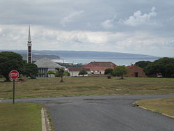
Town center with a view of the bay (to the east)
|
||
Stilbaai ( English Still Bay ) is a small tourist town in South Africa in the municipality of Hessequa , Garden Route District , Western Cape Province . It is located about 42 kilometers by road southeast of Riversdale , where the seat of the local community is located. Stilbaai stretches on both sides of the estuary from the Goukou River in Still Bay on the Indian Ocean .
description
The landscape surrounding the place belongs to the coastal plains of the Cape and is characterized by overgrown sand dunes . Its name is derived from that of the bay, which is known for its calm water conditions.
As an official administrative village, Stilbaai is considered a young settlement, although a very old pre-colonial settlement area existed here and European immigrants built houses here at least since the 19th century. Stilbaai was proclaimed a settlement in 1962 and was only granted the right to self-government in 1966 . In addition to the town center, there are the districts of Lappiesbaai , Stilbaai East , Stilbaaihoogte and Stilbaai West .
In 2011 Stilbaai had 3514 inhabitants. With its senior citizens' residence, the place has a special quality of life for the elderly.
To the west, Stilbaai borders on Groot Jongensfontein with 355 inhabitants.
Attractions
In the Stilbaai East district, a natural, vegetation-free dune landscape extends on the slope facing the sea. From the southernmost point of the coast within the local area there is an overview of the city, the mouth of the Goukou River and the coastline running to the east.
In some places on the coast there are remains of fish traps made from reading stones ("Vywer"), which have been preserved for centuries by the indigenous population, the Khoikhoi , and used for food in the interplay of the tidal water level . The arched wall strips from pre-colonial times are under monument protection and have to be continuously preserved, as the waves wash them out and dismantle them again.
In the village there are old farm buildings from the 19th century, which are now used by their owners for tourist purposes.
In the neighboring village of Melkhoutfontein there is a botanical garden with plants from the fynbos - biome of the coastal region. The facility, which opened in 2016, is operated by descendants of the indigenous population and is part of the Gouritz Cluster Biosphere Reserve .
Economy and Transport
Stilbaai has a beach, a pier for smaller ships and a golf course . The place lives mainly from its tourist offers, which include various forms of water sports and fishing , nature observation in the marine reserve of the bay and hikes in the dune landscape.
A bridge over the Goukou River near the Stilbaaihoogte district connects the center of the village on its west bank with the Lappiesbaai district on the east bank. There is a small landing strip for airplanes on both sides. The place can be reached by land via the 26-kilometer regional road R305, which branches off the national road N2 to the southeast at Riversdale .
Web links
- Still Bay Tourism / Stilbaai Toerisme: Stilbaai Tourism . on www.stilbaaitourism.co.za (English)
Individual evidence
- ^ A b Peter Edmund Raper : Dictionary of Southern African Place Names . Lowry Publishers, Johannesburg 1987 (2nd ed.), P. 304
- ↑ a b according to OSM
- ↑ 2011 census , accessed May 21, 2020
- ^ Western Cape Government: Stilbaai Tehuis . on www.westerncape.gov.za (English)
- ↑ 2011 census , accessed May 21, 2020
- ^ Still Bay Tourism / Stilbaai Toerisme: Heritage trips. Ancient fish traps . on www.stilbaaitourism.co.za (English)
- ^ John Gribble: Pre-Colonial Fish Traps On the South Western Cape Coast, South Africa . In: R. Grenier, D. Nutley, I. Cochran (Eds.): Underwater Cultural Heritage at Risk: Managing Natural and Human Impacts . P. 29–31, ICOMOS , Paris, online at www.icomos.org (English, PDF)
- ^ J. du Toit, C. Attwood, J. du Plessis, A. Boyd: Stilbaai Marine Protected Area Management Plan . (Department of Environmental Affairs and Tourism: Branch Marine and Coastal Management) Roggebaai 2008, online at www.mpaforum.org.za (English, PDF)
- ↑ a b Anonymous: Still Bay, Garden Route . on www.sa-venues.com (English)
- ↑ Dreamcatcher South Africa: La Bloemen Botanical Garden . on www.dreamcatchersouthafrica.com (English)
- ^ Megan Adderley (IM): Still Bay . on www.stilbaai-info.co.za (English), tourist information about the place

