Garden Route (District)
| Garden Route Garden Route District Municipality |
||
|---|---|---|
 |
||
| Symbols | ||
|
||
| Basic data | ||
| Country | South Africa | |
| province | Western cape | |
| Seat | George | |
| surface | 23,331 km² | |
| Residents | 574,265 (October 2011) | |
| density | 25 inhabitants per km² | |
| key | DC4 | |
| ISO 3166-2 | ZA toilet | |
| Website | www.gardenroute.gov.za (English) | |
| politics | ||
| mayor | Memory Booysen | |
Coordinates: 34 ° 10 ′ S , 22 ° 8 ′ E
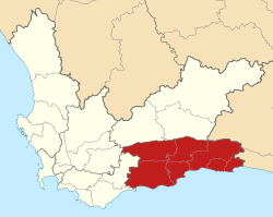
Garden Route ( Garden Route District Municipality , Afrikaans Tuinroete-distriksmunisipaliteit , until mid-2018 Eden ) is a district within the Western Cape Province in South Africa . It has 574,265 inhabitants (as of October 2011) on a total area of 23,331 km². The seat of the district administration is George .
The district is named after the Garden Route . The earlier name referred to the Garden of Eden .
The district is divided into the following municipalities:
Neighboring districts are:
National parks and nature reserves
- Goukamma Nature Reserve
- Kammanassie Nature Reserve
- Keurbooms River Nature Reserve
- Outeniqua Nature Reserve
- Robberg Nature Reserve
Web links
- Portrait at localgovernment.co.za (English)
Individual evidence
- ^ Census 2011. Basic Results. (PDF; 349 kB) Statistics South Africa , accessed on November 27, 2015 (English).