
Oudtshoorn (municipality)
| Oudtshoorn Oudtshoorn Local Municipality |
||
|---|---|---|
.svg) |
||
| Symbols | ||
|
||
| Basic data | ||
| Country | South Africa | |
| province | Western cape | |
| District | Garden Route | |
| Seat | Oudtshoorn | |
| surface | 3537 km² | |
| Residents | 95,933 (October 2011) | |
| density | 27 inhabitants per km² | |
| key | WC045 | |
| ISO 3166-2 | ZA toilet | |
| Website | www.oudtmun.gov.za (English) | |
| politics | ||
| mayor | Colan New Years Eve | |
 |
||

Coordinates: 33 ° 34 ′ S , 22 ° 11 ′ E
Oudtshoorn is a municipality in the Garden Route District, Western Cape Province in South Africa . In 2011 the population was 95,933 inhabitants on a total area of 3,537 km². The seat of the municipal administration is in Oudtshoorn . The community is named after Baron van Rheede van Oudtshoorn, former governor of the Cape, who died in 1773 on a sea voyage to the Cape.
Cities / towns
- De Rust
- Dysselsdorp
- Grootkraal
- Kruisrivier
- Le Roux
- Matjiesrivier
- Oudtshoorn
- Schoemanshoek
- Stolsvlakte
- Vlakteplaas
- Volmoed
- Waaikraal
population
In 2011 the community had 95,933 inhabitants. 77.3% of these were colored , 12.5% white and 9.1% black.
88.9 % of the speakers were Afrikaans, 4.7% IsiXhosa and 2.2% English.
Attractions

The stalactite cave Cango Caves near Oudtshoorn
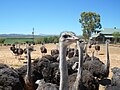
An ostrich farm near Oudtshoorn

The Swartberge near Oudtshoorn


Web links
Commons : Oudtshoorn - collection of images, videos and audio files
- Portrait at localgovernment.co.za (English)