
Stolbowoi
| Stolbowoi | ||
|---|---|---|
 |
||
| Waters | Laptev Lake | |
| Archipelago | Lyakhov Islands ( New Siberian Islands ) | |
| Geographical location | 74 ° 4 ′ N , 135 ° 49 ′ E | |
|
||
| length | 46.7 km | |
| width | 10.3 km | |
| surface | 170 km² | |
| Highest elevation | 222 m | |
| Residents | uninhabited | |

Stolbowoi ( Russian Столбовой остров , "Pillar Island") is an approximately 170 km² large Russian island in the Arctic Laptev Sea, belonging to the Lyachow Islands (southern part of the New Siberian Islands ) .
The highest elevation of the uninhabited island, which is 46.7 km long in the northwest-southeast direction between the capes Mys Skalisty and Mys Poworotny and up to 10.3 km wide in the southwest-northeast direction, is 222 m in the southeast part. Its surface consists largely of granite , the vegetation corresponds to that of the tundra .
The island was discovered by the Russian explorer, trader and cartographer Jakow Sannikow in 1800 and mapped by Pyotr Anjou in 1821 . Adolf Erik Nordenskiöld passed the island on board the Vega on August 28, 1878, while he was the first to cross the Northeast Passage .
- cards
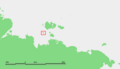
Situation map

Map of the New Siberian Islands
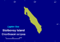
Map of Stolbowoi


literature
- Stolbowoi Ostrow . In: Энциклопедический словарь Брокгауза и Ефрона - Enziklopeditscheski slowar Brokgausa i Jefrona . tape 31 a [62]: Статика – Судоустройство. Brockhaus-Efron, Saint Petersburg 1901, p. 683 (Russian, full text [ Wikisource ] PDF ).
- G. Gilbo: Sprawotschnik po istorii geografitscheskich naswani na pobereschje SSSR. Ministerstwo oborony Soiusa SSR, Glaw. upr. nawigazii i okeanografii, 1985, p. 329 (Russian).
Individual evidence
- ↑ Topographic map (1: 200.000, Bl. S-53-XI, XII, Ed. 1987)
- ^ Adolf Erik Nordenskiöld: The circumnavigation of Asia and Europe on the Vega with a historical review of earlier journeys along the north coast of the Old World , Brockhaus, Leipzig 1882, p. 375 .
Web links
- Article Stolbowoi in the Great Soviet Encyclopedia (BSE) , 3rd edition 1969–1978 (Russian)
Lyakhov Islands : Big Lyakhov Island | Yeah | Little Lyakhov Island | Stolbowoi
Anjou Islands : Belkovsky Island | Bungeland | Faddejewski Peninsula | Kotelny Island New Siberia | Strischow Island
De Long Islands : Bennett Island | Henrietta Island | Jeannette Island | Shokhov Island | Wilkizki Island
former islands: Semyonovsky Island | Vasilyevsky Island
Sannikow Land (Phantom Island)