
Stymfalia
|
Parish of Stymfalia Δημοτική Ενότητα Στυμφαλίας (Στυμφαλία) |
|||
|---|---|---|---|
|
|||
| Basic data | |||
| State : |
|
||
| Region : |
Peloponnese
|
||
| Regional District : | Corinthia | ||
| Municipality : | Sikyona | ||
| Geographic coordinates : | 37 ° 52 ′ N , 22 ° 28 ′ E | ||
| Height above d. M .: | 667 - 700 - 980 m Stymfalia - Kaliani - Kyllini |
||
| Area : | 205.070 km² | ||
| Residents : | 2,427 (2011) | ||
| Population density : | 11.8 inhabitants / km² | ||
| Code No .: | 420602 | ||
| Structure: | 10 local communities | ||
| Located in Sikyona Municipality and Korinthia Regional Unit | |||
 |
|||

Stymfalia ( Greek Στυμφαλία ( f. Sg. )) Is a village, a district of the municipality of Sikyona , a standing body of water and a plateau in the prefecture of Korinthia in the northeast of the Peloponnese , Greece .
Stymfalia was recognized as a rural community (kinotita) under the name Matsiza (19άτσιζα) in 1924 and renamed to its current name in 1927. In 1997, a municipality (dimos) was established through numerous incorporations of surrounding villages , which had its seat in the village of Kaliani. This parish came to Sikyona on January 1, 2011, where it has been a parish since then.
geography
Stymfalia is a plateau (600 m) which is completely surrounded by mountain ranges, some of which are very high. The plains and the surrounding area are - as is predominant in most of the Peloponnese - karst formations.
The mountain ranges that border the plain to the south are predominantly steeply rising. On the eastern shore of the lake the ridge sinks and allows a road pass height of approx. 150 m. Over this pass you can reach the cities of Tripoli (50 km) to the southwest and Nemea (20 km) and Corinth (50 km), the center of the prefecture and gateway to Athens , to the northeast .
Depending on the season, the lake extends about 3 to 5 km long and 1 to 1.5 km wide. It has no above-ground drain. The surroundings, the plain and the lake form a remarkable geosystem with a picturesque nature and several valuable biotopes . In terms of its (hydro) geological properties, the plain differs from the numerous other karst basins ( Polje ) of the Peloponnese: The water surface of the Polje almost never falls dry in the typically rain-free, hot seasons.
For the geology , hydrogeology , biotopes and nature of Stymfalia cf. Stymfalia (ecosystem) .
Land use
Conditions for safe, productive agriculture are only given at a sufficient distance from the lake. As a result of abundant winter rainfall, but hardly any surface runoff, but mainly fed by three heavily pouring karst springs and as a result of extremely dry summers, the extent of the lake fluctuates greatly. This is why the cultivated areas are often too wet or swampy, especially in the times of sowing and early growth, and in the vicinity of the lake they are often flooded until the end of May due to insufficient runoff. The lake floods the west side more strongly. Drainage ditches are the rule. Irrigation ditches fed by the long-pouring springs bridge the summer drought. Some orchards indicate restrictions on agriculture. The alluvial and debris cones of the mountains - more common in the western part of the plain - are cultivated in their lower parts through terracing and are generally still used.
environment
The surrounding mountains are densely forested up to the heights. Biting sheep and goats on the mountains or in the usable slope areas, as can still be observed today in many other places in the Peloponnese, is no problem in the Stymfal Basin. The lake, its surroundings and the Oligyrtos Mountains to the south form particularly valuable ecosystems (biotopes and geotopes, special animal species, resting places for migratory birds). They are therefore planned as two Natura 2000 areas . The protected status of the habitats had not yet occurred in 2006. Attempts by particular interests in the 1980s to significantly change the water balance of the plain through interventions still failed. The silting up by reed vegetation, caused by silting, agricultural irrigation and fertilization ( eutrophication / overfertilization ) increased. It grew from 33% in 1945 to 55% in 2003. (natura.minenv.gr)
Nature conservation and EU protection norms collide with state and local authority interests in economic, settlement and infrastructural development. Because the Peloponnese is - with the exception of the very few cities and agglomerations on the north coast - threatened by ongoing migration and thus infrastructurally dangerous thinning.
The extraction of water for the eastern coastal area of the Gulf of Corinth was realized around 130 by the philhellenic Roman emperor Hadrian through the aqueduct of Corinth . On the “small scale” of the technical possibilities at the time, the water abstraction did not seriously affect the environmental conditions for Stymfalia. The interventions that have been occurring since this 21st century, such as road construction, agricultural irrigation and drainage, chemical fertilization, sea level regulation through a contained, regulated karst sinkhole and a large-volume water pipeline system, make a sustainable development path very difficult and economically expensive.
Settlement and economy
Apart from traditional agriculture, there are hardly any jobs on the plain. Trade and handicrafts just cover the level's own needs. The settlement of commercial enterprises with a need for space and a further expansion of traffic routes to the regional centers would run counter to the protection purposes of the Natura 2000 habitats.
Seasonal tourism ties in with the classical, mythological and archaeological aspects. Stymfalia is archaeologically, geographically and traffic-wise marginal for the economic factor tourism, which is very important for Greece.
Villages
The following local communities and settlements belong to the municipality
- Asprokambos (Ασπρόκαμπος, 211 Ew.)
- Drosopigi (Δροσοπηγή, 65 Ew.)
- Kesario (Καισάριον, 497 Ew.)
- Kaliani (Καλιανοί, 174 Ew.)
- Kastanea (Καστανιά, 107 Ew.) With
- Karteri (Καρτέρι, 96 Ew.)
- Mikros Machalas (Μικρός Μαχαλάς, 11 Ew.)
- Kefalari (Κεφαλάρι, 251 Ew.)
- Kyllini (Κυλλήνη, 114 Ew.)
- Lafka (Λαύκα, 362 Ew.)
- Psari (Ψάρι, 355 Ew.)
- Stymfalia (Στυμφαλία, 151 Ew.) With
- Kionia (Κιόνια, 33 Ew.)
Since only a few agricultural areas provide reliable yields, the villages are small. The number of people who live here permanently has tended to decrease so far.
photos
 Stymfalia village, Ziria massif , fields still wet, ditch (sea border) in front of Hadrian's tunnel entrance
 Fertile plains, lake with flooding, snow in the Ziria massif (2,374 m), WorldWind (8 km)
 Oligyrtos massif, 100% forest; Floods: green reeds, wet fields
 Growing reeds (green), densely forested
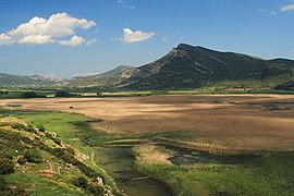 Remnants of the city wall, gate, houses; permanent lake area: reeds, ocher colored


Web links
- natura.minenv.gr - Limni Stymfalia ( Memento from July 21, 2011 in the Internet Archive )
Individual evidence
- ↑ Results of the 2011 census at the National Statistical Service of Greece (ΕΛ.ΣΤΑΤ) ( Memento from June 27, 2015 in the Internet Archive ) (Excel document, 2.6 MB)