
Suriname (river)
|
Suriname Sranan liba |
||
.jpg) Map Zimmermann 1877 |
||
| Data | ||
| location | Suriname | |
| River system | Suriname | |
| muzzle | north of Paramaribo in the Atlantic Coordinates: 5 ° 55 ′ 30 " N , 55 ° 10 ′ 16" W 5 ° 55 ′ 30 " N , 55 ° 10 ′ 16" W
|
|
| length | 480 km | |
| Left tributaries | Para | |
| Right tributaries | Commewijne | |
| Reservoirs flowed through | Brokopondo reservoir | |
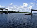
 Paramaribo, by ferry across the river. In the background the Wijdenbosch bridge and on the right the wreck of the Goslar . (February 2000) |
||
The Suriname ( Sranantongo Sranan liba 'Suriname River') is a river in the Republic of Suriname ( South America ) that is divided in half by the Brokopondostuw Sea ( reservoir ).
River course
It rises as Gran-Rio on the northern slope of the Eilerts-de-Haan Mountains in the extreme southwest of the Sipaliwini district . The river flows in north-east direction and forms the Sintidam with the Adidon- and Adindinfällen forms the Awara- and after the first Marrondörfer happened, the Grandam with the Tapawatrafall . At Godo the Gran Rio joins the Pikin Rio (small river). Between Godo and the mouth of the reservoir, north of Pokigron , the Suriname flows northwards through the more densely populated area of the Saramaccans and forms various smaller and larger waterfalls : the Toni- , Bofrokule- , Dahome- , Ejkununu- , Bia-ati- , Vedubuka , Jin-Jin , Kuna , Jemongo , Ferulasi , Jaw-Jaw , Apresina and Bakaaboto cases . Over the reservoir it receives its former rivers flowing in from the right, the Gran or Marowijne and the Sarakreek . The river leaves the reservoir through the hydroelectric power station of the dam near Afobaka and continues to flow northwards. At Victoria the river bends to the west, flows again via Berg en Dal to the north and takes on the Mama , Klaas and Marchealkreek . Here he passes the transmigration villages Klaaskreek and Nieuw-Lombè . At the beginning of the 1960s, according to official information, around 6,000 Marrons had to leave their old villages and places of worship for the reservoir and some of them were settled here.
At Paranam the river forms a large arch and further north follows the arch of Waterland , where the river flows in from the right . Behind Domburg , Suriname takes in the Pauluskreek from the right and the Para River and the Saramacca Canal from the left . It passes Paramaribo and Meerzorg on the other bank .
Here the river is 900 meters wide. Directly next to the market halls in Paramaribo and in Meerzorg there are landing stages for the small ferry boats that run at irregular intervals. At Nieuw-Amsterdam the Commewijne joins from the right and the Suriname flows into the Atlantic behind the fishing village Pamona , at the sandy tongue of Braamspunt .
shipping
The Suriname is by far the most important river in Suriname for import and export. Not only do all ships with bauxite and aluminum leave the country via this, but almost all ships that deliver the goods and goods that are essential for Suriname come into the country via Braamspunt to unload their cargo in the port of Paramaribo (immediately south of the city center). The ports of the bauxite industry are located around 30 km south of Paramaribo, in Smalkalden and Paranam.
In front of Paramaribo, a ship of the German merchant navy, the Goslar , sunk by crew members on the orders of the captain, juts out of the water. The ship was flooded shortly after the German Wehrmacht invaded the Netherlands in May 1940 in order to thwart its seizure by the Dutch colonial power.
bridges
In May 2000, the Jules Wijdenbosch Bridge in Paramaribo was inaugurated and opened to traffic. It is the first bridge over the Suriname in the capital. It is named after the client and then president. The bridge opens up the eastern part of Suriname.
At Carolina in the Para district , about 50 km south of Paramaribo, a wooden bridge connected the two banks. This bridge was no longer passable after a ship collision and was demolished. The new bridge was last severely damaged by ship collisions in 2007, shortly before completion, and had to be replaced. On December 21, 2014, the "Carolinabrücke", which was newly built about 5 km upstream from the old site, was officially opened to traffic. This steel structure is 204 m long and 12.5 m wide.
- Photo gallery Suriname River

Paramaribo, on the left the market halls, next to it the ferry

Old, broken wooden bridge near Carolina (February 2000)

The new, badly damaged bridge near Carolina (March 2008)
Carolinabrücke from the river (September 2011)

Bridge at Afobaka


Some numbers
The catchment area of the river is 16,500 km²; of which above the reservoir, at Pokigron (250 kilometers from the mouth), 7,750 km². The length of the estuary is around 140 kilometers. The mean tidal range in the estuary is 1.8 meters, the average tidal volume is 120 million cubic meters. The salt border extends about 40 km inland to the confluence of the Pauluskreek .
exploration
Up to Brokopondo, Suriname was already known in the early days of colonization - and so was the upper reaches mainly through the missionary work of the Moravian Brethren among the Saramaccans in the 18th and 19th centuries. The scientific exploration of the river began in 1885 by the German geologist Karl Martin, who drove up the river to the Marron village of Toledo, published under: Geological studies on the Dutch West Indies , Leiden 1888, and was carried out by the so-called Suriname expedition under Eilerts de Haan in 1908 -1909 continued. Martin's work contains the first general map of Suriname with geological information; he also gives optimistic descriptions of iron ore deposits.
The name
The first real sources are Sir Walter Raleigh (1595) and Lawrence Keymis (1596), who sailed the river and named Suriname. There are more than 30 variants of the spelling of the river in maps and literature. The name is probably derived from the old indigenous Indian tribe, the Surines , and was later transferred to the country as a civic name.
literature
- CFA Bruijning and J. Voorhoeve (red.): Encyclopedie van Suriname . Elsevier , Amsterdam a. Brussel 1977, pp. 227, 591-592, ISBN 90-10-01842-3 .
Web links
Individual evidence
- ↑ Ministry of Regional Development, February 1, 2014 50 Years of Resettlement Remembrance Day ( Memento of March 10, 2014 in the Internet Archive ) Dutch, accessed on March 18, 2016
- ↑ StarNieuws, December 23, 2014 in Dutch, accessed November 19, 2016