Symington (South Lanarkshire)
| Symington | ||
|---|---|---|
| Symington House | ||
| Coordinates | 55 ° 36 ′ N , 3 ° 36 ′ W | |
|
|
||
| Residents | 693 2011 census | |
| administration | ||
| Post town | BIGGAR | |
| ZIP code section | ML12 | |
| prefix | 01899 | |
| Part of the country | Scotland | |
| Council area | South Lanarkshire | |
| British Parliament | Dumfriesshire, Clydesdale and Tweeddale | |
| Scottish Parliament | Clydesdale | |
Symington is a village in the east of the Scottish Council Area South Lanarkshire or in the traditional county of Lanarkshire . It is located about 13 kilometers southeast of Lanark on the western flank of the Culter Hills . The Tinto rises to the west .
history
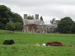
From the 1860s, the village developed at a branch of a railway line. In 1915 the neo-historic villa Symington House was built.
While 373 people lived in Symington in 1961, the 2011 census survey counted 693 residents.
traffic
The A72 ( Galashiels - Hamilton ) forms the main thoroughfare of Symingtons and connects the village directly to the trunk road network. The A73 ( Abington - Cumbernauld ) and the A702 ( Edinburgh - St John's Town of Dalry ) are within a few kilometers.
Symington was once the end point of the Symington, Biggar and Broughton Railway , which flowed into what is now the West Coast Main Line . The main line connecting Edinburgh and Glasgow with London continues through the town. However, the station was abandoned. The Symington, Biggar and Broughton Railway closed in the middle of the 20th century.
Individual evidence
- ↑ a b Entry in the Gazetteer for Scotland
- ↑ Listed Building - Entry . In: Historic Scotland .
- ^ Information in the Gazetteer for Scotland
- ↑ 2011 census data

