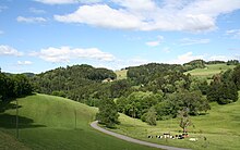
Tössbergland


The Tössbergland (also Hörnli area ) is 700 to 1300 m above sea level. M. high hill and mountain area in Switzerland , which lies in the east of the canton of Zurich ( Zürcher Oberland ) on the border with Toggenburg . Geographically and geologically, the Tössbergland is assigned to the Central Plateau despite its distinctive relief differences ; comparable to Napf and Rigi .
Well-known elevations are the Hörnli , the Schnebelhorn , the Tössstock and the Bachtel to the west .
geology
The geological history of the Tössbergland is closely related to the folding of the Alps . After this folding began around 30 million years ago, erosion quickly set in. Rivers transported the rock fragments to the basin north of the Alps , today's Mittelland , and deposited them there. In places where large rivers reached the basin, extensive alluvial cones , also called Nagelfluh fans , formed over time . The Nagelfluh is a composite rock consisting of rounded rocks of various sizes transported through rivers. These chunks are held together by a fine binding agent that fills the cavities.
vegetation
The core area of the Tössbergland in particular is covered by extensive forests, with mixed forests above around 800 to 900 m , including mainly beech forests . Forested are mainly the partly extremely steep slopes, as well as the remote deep valley valleys . Meadows and pastures predominate on the ridges and the less steep areas .
Cultural landscape
Apart from the villages in the valley, especially the Töss Valley, the Tössbergland is a very sparsely populated region. It is a typical scattered settlement area with small hamlets , which are mostly located in the valleys, and numerous individual farms that are widely scattered both in the valleys and on the ridges (harrows). These homesteads are often very remote and difficult to reach. The residents live from livestock and grass management, as well as from forestry and wood processing . Arable farming is only practiced in favorable valleys and in the less strongly undulated areas.
Over time, charcoal burning developed , which meant that the area was partially cleared. But because the stabilizing effect of the slopes by the trees no longer existed , the valleys and the villages of the lowlands were repeatedly exposed to the risk of flooding , with the Töss , which is now tamed, as the original torrent, and carried large amounts of debris with it.
Today the Zurich Oberland is a popular hiking and mountain biking region.
literature
- Thomas Bolliger, Hans Gatti, Rene Hantke, "On the geology and palaeontology of the Zurich Oberland" , quarterly journal of the Natural Research Society in Zurich 133/1 (1988), 1-24.
Web links
- Tössbergland Swissview on youtube.com
- Schnebelhorn on outdooractive.com
