
Horse Mesa Dam
| Horse Mesa Dam | ||
|---|---|---|
 |
||
| location | ||
|
||
| Coordinates | 33 ° 35 '27 " N , 111 ° 20' 38" W | |
| country |
|
|
| place | Maricopa County , Arizona | |
| Waters | Salt River | |
| Height upstream | 583.4 m | |
| power plant | ||
| owner | Salt River Project (SRP) | |
| operator | SRP | |
| construction time | 1924 to 1927 | |
| Start of operation | 1927 | |
| technology | ||
| Bottleneck performance | 147 megawatts | |
| Average height of fall |
81 m | |
| Turbines | 3 × 11 MW, 1 × 115 MW | |
| Others | ||

The Horse Mesa dam ( English Horse Mesa Dam ) is a dam with hydroelectric power plant in Maricopa County , State of Arizona , USA . It dams the Salt River to a reservoir, Apache Lake . The dam is located approximately 104 km (65 miles ) northeast of Phoenix . The Theodore Roosevelt Dam is approximately 18 km upstream and the Mormon Flat Dam is approximately 22 km downstream.
Construction of the dam began in 1924. It was completed in 1927. The dam is primarily used to generate electricity. It is owned and operated by the Salt River Project (SRP) and is also operated by SRP.
Barrier structure
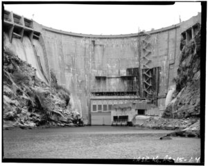
The shut-off is an arch dam of concrete with a height of 93 m (305 ft ) above the foundation bed . The top of the wall is at an altitude of 585 m (1920 ft) above sea level . The length of the top of the wall is 201 m (660 ft). The thickness of the dam is 17.4 m (57 ft) at the base and 2.4 m (8 ft) at the top. The volume of the structure is 123,858 m³ (162,000 cubic yards ).
The dam wall has both a flood relief (one on each side of the valley) and a bottom outlet . A maximum of 4247 m³ / s (150,000 cft / s) can be discharged via the flood discharge, and a maximum of 198 m³ / s (7000 cft / s) via the bottom outlet.
Reservoir
At the normal storage target of 583.4 m (1914 ft), the reservoir extends over an area of around 10.75 km² (2656 acres ) and holds 302.37 million m³ (245,138 acre-feet ) of water.
power plant
The power plant is located at the foot of the dam. The installed capacity is 147 MW ; it was originally 32 MW. The three initially installed turbines each have a maximum output of 9.9 (or 11) MW. In 1972 an additional pump turbine with an output of 97 MW was installed. The pump turbine was renewed in 2002; an increase in output to 115 MW was carried out. The annual generation fluctuates: in 2003 it was around 231.6 million kWh and in 2007 around 64.5 million kWh . The drop height is 81 m (266 ft).
history

The Theodore Roosevelt Dam, completed in 1911, was built to compensate for the uneven flow regime of the Salt River and to create a storage space that would enable orderly irrigation in the lower reaches of the Salt River. The water from the reservoir should only be drained from April 1st to October 1st of each year to be used for irrigation purposes.
Electricity generation at the Roosevelt Dam Power Station was initially just a by-product. However, during World War I, the demand for electricity increased and the managers of the Salt River Valley Water Users' Association (the predecessor organization of the Salt River Project ) saw it as an opportunity to generate additional income by increasing electricity generation. However, this raised concerns among the Association's landowners that the water would now be used to generate electricity instead of irrigation.
This ultimately led to the plan to build further dams on the Salt River below the Roosevelt Dam in order to be able to use the water several times. In the 1920s, the Mormon Flat Dam (1923 to 1925), the Horse Mesa Dam (1924 to 1927) and the Stewart Mountain Dam (1928 to 1930) were built.
The total costs for the construction of the dam and the power plant are given as 4.237 million USD .
See also
Web links
Individual evidence
- ^ A b c d The Salt River Project, Arizona. (PDF) uair.library.arizona.edu, pp. 1, 6 , accessed on December 3, 2018 (English).
- ↑ a b Horse Mesa Dam. United States Bureau of Reclamation (USBR), accessed December 1, 2018 .
- ↑ a b Horse Mesa Dam. Salt River Project (SRP), accessed December 3, 2018 .
- ^ A b Horse Mesa Hydro Power Plant AZ USA. Global Energy Observatory, accessed December 1, 2018 .
- ^ Salt River Project. (PDF) USBR, p. 16 (17) , accessed on December 6, 2018 (English).
- ^ Sticky Wickets: Modifying Operation of a Pumped Storage Project. www.hydroworld.com, December 5, 2014, accessed December 1, 2018 (English).
- ^ A b c Arizona: Roosevelt Dam and Powerplant. National Park Service (NPS), accessed December 9, 2018 .
- ^ Water and Electricity: Not always a deadly combination. USBR, accessed December 1, 2018 .